You are here: Home > Network List > US - United States National Seismic Network Stations List
> Station WUAZ Wupatki, Arizona, USA > Earthquake Result Viewer
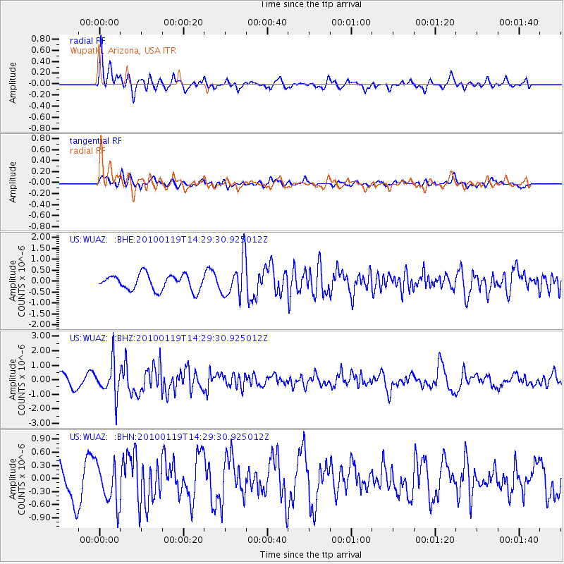
WUAZ Wupatki, Arizona, USA - Earthquake Result Viewer
*The percent match for this event was below the threshold and hence no stack was calculated.
| Earthquake location: |
Cuba Region |
| Earthquake latitude/longitude: |
19.0/-80.8 |
| Earthquake time(UTC): |
2010/01/19 (019) 14:23:38 GMT |
| Earthquake Depth: |
10 km |
| Earthquake Magnitude: |
5.7 MB, 5.4 MS, 5.9 MW, 5.9 MW |
| Earthquake Catalog/Contributor: |
WHDF/NEIC |
|
| Network: |
US United States National Seismic Network |
| Station: |
WUAZ Wupatki, Arizona, USA |
| Lat/Lon: |
35.52 N/111.37 W |
| Elevation: |
1592 m |
|
| Distance: |
31.6 deg |
| Az: |
307.631 deg |
| Baz: |
113.287 deg |
| Ray Param: |
$rayparam |
*The percent match for this event was below the threshold and hence was not used in the summary stack. |
|
| Radial Match: |
66.25823 % |
| Radial Bump: |
400 |
| Transverse Match: |
34.819824 % |
| Transverse Bump: |
400 |
| SOD ConfigId: |
296938 |
| Insert Time: |
2010-04-06 22:14:15.672 +0000 |
| GWidth: |
2.5 |
| Max Bumps: |
400 |
| Tol: |
0.001 |
|
Signal To Noise
| Channel | StoN | STA | LTA |
| US:WUAZ: :BHZ:20100119T14:29:30.925012Z | 2.3900769 | 1.1756769E-6 | 4.9189913E-7 |
| US:WUAZ: :BHN:20100119T14:29:30.925012Z | 1.1647092 | 4.6901485E-7 | 4.0268839E-7 |
| US:WUAZ: :BHE:20100119T14:29:30.925012Z | 2.5288956 | 8.8594476E-7 | 3.5032872E-7 |
| Arrivals |
| Ps | |
| PpPs | |
| PsPs/PpSs | |


