You are here: Home > Network List > US - United States National Seismic Network Stations List
> Station MNTX Cornudas Mountains, Texas, USA > Earthquake Result Viewer
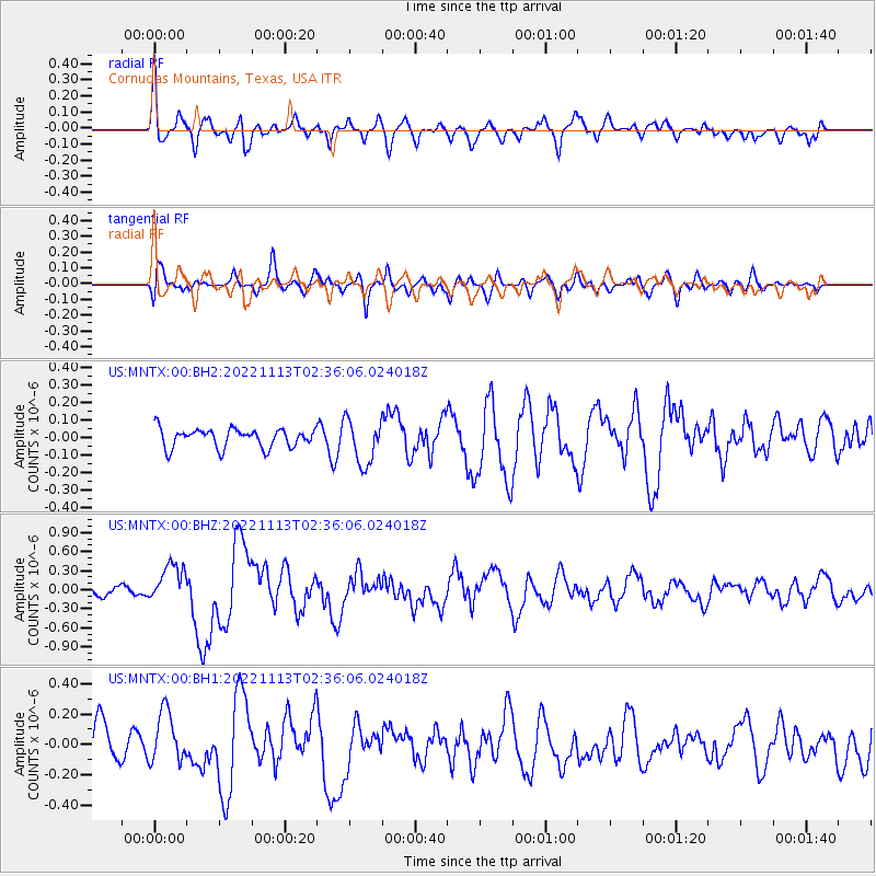
MNTX Cornudas Mountains, Texas, USA - Earthquake Result Viewer
*The percent match for this event was below the threshold and hence no stack was calculated.
| Earthquake location: |
Near Coast Of Central Chile |
| Earthquake latitude/longitude: |
-37.5/-73.7 |
| Earthquake time(UTC): |
2022/11/13 (317) 02:24:57 GMT |
| Earthquake Depth: |
18 km |
| Earthquake Magnitude: |
6.2 mww |
| Earthquake Catalog/Contributor: |
NEIC PDE/us |
|
| Network: |
US United States National Seismic Network |
| Station: |
MNTX Cornudas Mountains, Texas, USA |
| Lat/Lon: |
31.70 N/105.38 W |
| Elevation: |
405 m |
|
| Distance: |
74.9 deg |
| Az: |
332.407 deg |
| Baz: |
154.379 deg |
| Ray Param: |
$rayparam |
*The percent match for this event was below the threshold and hence was not used in the summary stack. |
|
| Radial Match: |
59.048336 % |
| Radial Bump: |
400 |
| Transverse Match: |
61.242588 % |
| Transverse Bump: |
400 |
| SOD ConfigId: |
29756493 |
| Insert Time: |
2022-11-27 03:13:01.038 +0000 |
| GWidth: |
2.5 |
| Max Bumps: |
400 |
| Tol: |
0.001 |
|
Signal To Noise
| Channel | StoN | STA | LTA |
| US:MNTX:00:BHZ:20221113T02:36:06.024018Z | 3.7843568 | 3.02059E-7 | 7.981779E-8 |
| US:MNTX:00:BH1:20221113T02:36:06.024018Z | 1.4333897 | 1.7010116E-7 | 1.1867057E-7 |
| US:MNTX:00:BH2:20221113T02:36:06.024018Z | 2.3679173 | 1.2665164E-7 | 5.348652E-8 |
| Arrivals |
| Ps | |
| PpPs | |
| PsPs/PpSs | |


