You are here: Home > Network List > CI - Caltech Regional Seismic Network Stations List
> Station SMM Simmler, CA, USA > Earthquake Result Viewer
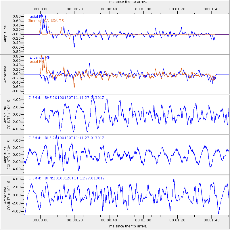
SMM Simmler, CA, USA - Earthquake Result Viewer
*The percent match for this event was below the threshold and hence no stack was calculated.
| Earthquake location: |
Haiti Region |
| Earthquake latitude/longitude: |
18.4/-72.8 |
| Earthquake time(UTC): |
2010/01/20 (020) 11:03:43 GMT |
| Earthquake Depth: |
10 km |
| Earthquake Magnitude: |
5.9 MB, 5.8 MS, 5.9 MW, 5.9 MW |
| Earthquake Catalog/Contributor: |
WHDF/NEIC |
|
| Network: |
CI Caltech Regional Seismic Network |
| Station: |
SMM Simmler, CA, USA |
| Lat/Lon: |
35.31 N/120.00 W |
| Elevation: |
599 m |
|
| Distance: |
44.9 deg |
| Az: |
301.788 deg |
| Baz: |
99.339 deg |
| Ray Param: |
$rayparam |
*The percent match for this event was below the threshold and hence was not used in the summary stack. |
|
| Radial Match: |
64.64362 % |
| Radial Bump: |
400 |
| Transverse Match: |
54.52753 % |
| Transverse Bump: |
400 |
| SOD ConfigId: |
296938 |
| Insert Time: |
2010-04-06 22:17:04.536 +0000 |
| GWidth: |
2.5 |
| Max Bumps: |
400 |
| Tol: |
0.001 |
|
Signal To Noise
| Channel | StoN | STA | LTA |
| CI:SMM: :BHZ:20100120T11:11:27.01301Z | 1.5482727 | 1.8571927E-6 | 1.1995255E-6 |
| CI:SMM: :BHN:20100120T11:11:27.01301Z | 1.0909803 | 2.0563327E-6 | 1.8848488E-6 |
| CI:SMM: :BHE:20100120T11:11:27.01301Z | 1.6271957 | 3.1864217E-6 | 1.958229E-6 |
| Arrivals |
| Ps | |
| PpPs | |
| PsPs/PpSs | |


