You are here: Home > Network List > N4 - Central and EAstern US Network Stations List
> Station N51A Ashland, OH, USA > Earthquake Result Viewer
N51A Ashland, OH, USA - Earthquake Result Viewer
| Earthquake location: |
North Pacific Ocean |
| Earthquake latitude/longitude: |
31.5/-133.4 |
| Earthquake time(UTC): |
2022/11/02 (306) 04:53:13 GMT |
| Earthquake Depth: |
10 km |
| Earthquake Magnitude: |
6.0 mww |
| Earthquake Catalog/Contributor: |
NEIC PDE/us |
|
| Network: |
N4 Central and EAstern US Network |
| Station: |
N51A Ashland, OH, USA |
| Lat/Lon: |
40.92 N/82.37 W |
| Elevation: |
343 m |
|
| Distance: |
41.7 deg |
| Az: |
62.298 deg |
| Baz: |
273.729 deg |
| Ray Param: |
0.073641665 |
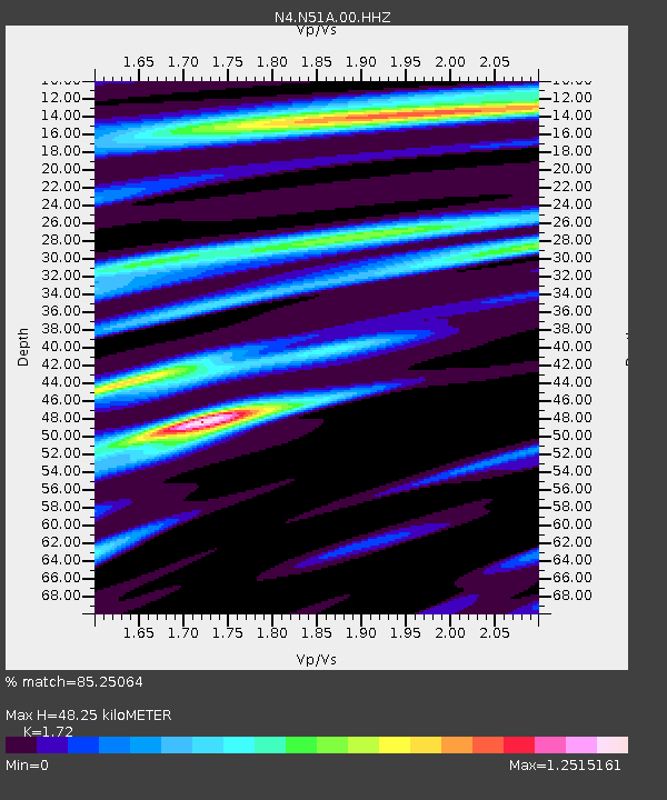
| Estimated Moho Depth: |
48.25 km |
| Estimated Crust Vp/Vs: |
1.72 |
| Assumed Crust Vp: |
6.498 km/s |
| Estimated Crust Vs: |
3.778 km/s |
| Estimated Crust Poisson's Ratio: |
0.24 |
|
| Radial Match: |
85.25064 % |
| Radial Bump: |
370 |
| Transverse Match: |
67.090744 % |
| Transverse Bump: |
400 |
| SOD ConfigId: |
29823551 |
| Insert Time: |
2022-11-27 21:36:06.252 +0000 |
| GWidth: |
2.5 |
| Max Bumps: |
400 |
| Tol: |
0.001 |
|

Signal To Noise
| Channel | StoN | STA | LTA |
| N4:N51A:00:HHZ:20221102T05:00:31.080013Z | 4.3781395 | 9.2692267E-7 | 2.1171611E-7 |
| N4:N51A:00:HH1:20221102T05:00:31.080013Z | 1.3459681 | 3.139532E-7 | 2.3325455E-7 |
| N4:N51A:00:HH2:20221102T05:00:31.080013Z | 2.0191002 | 5.019085E-7 | 2.485803E-7 |
| Arrivals |
| Ps | 5.7 SECOND |
| PpPs | 19 SECOND |
| PsPs/PpSs | 25 SECOND |


