You are here: Home > Network List > IU - Global Seismograph Network (GSN - IRIS/USGS) Stations List
> Station KIP Kipapa, Hawaii, USA > Earthquake Result Viewer
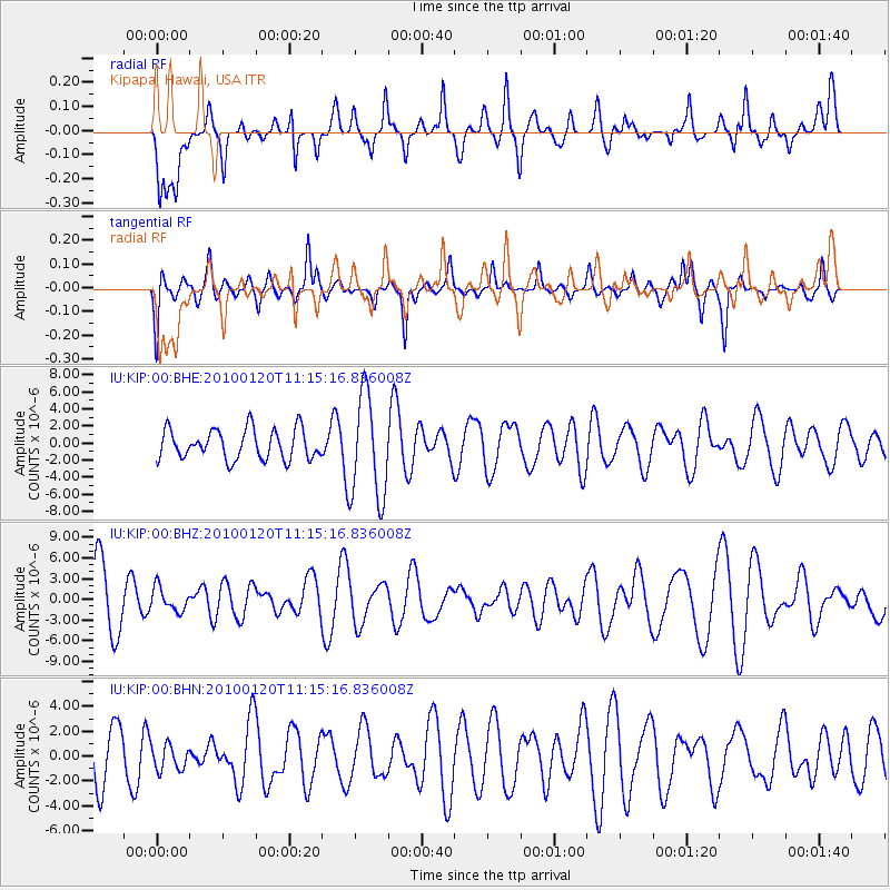
KIP Kipapa, Hawaii, USA - Earthquake Result Viewer
*The percent match for this event was below the threshold and hence no stack was calculated.
| Earthquake location: |
Haiti Region |
| Earthquake latitude/longitude: |
18.4/-72.8 |
| Earthquake time(UTC): |
2010/01/20 (020) 11:03:43 GMT |
| Earthquake Depth: |
10 km |
| Earthquake Magnitude: |
5.9 MB, 5.8 MS, 5.9 MW, 5.9 MW |
| Earthquake Catalog/Contributor: |
WHDF/NEIC |
|
| Network: |
IU Global Seismograph Network (GSN - IRIS/USGS) |
| Station: |
KIP Kipapa, Hawaii, USA |
| Lat/Lon: |
21.42 N/158.01 W |
| Elevation: |
110 m |
|
| Distance: |
79.1 deg |
| Az: |
289.025 deg |
| Baz: |
74.421 deg |
| Ray Param: |
$rayparam |
*The percent match for this event was below the threshold and hence was not used in the summary stack. |
|
| Radial Match: |
62.53276 % |
| Radial Bump: |
400 |
| Transverse Match: |
52.500618 % |
| Transverse Bump: |
360 |
| SOD ConfigId: |
296938 |
| Insert Time: |
2010-04-06 22:19:32.517 +0000 |
| GWidth: |
2.5 |
| Max Bumps: |
400 |
| Tol: |
0.001 |
|
Signal To Noise
| Channel | StoN | STA | LTA |
| IU:KIP:00:BHZ:20100120T11:15:16.836008Z | 0.3760966 | 1.6987292E-6 | 4.516736E-6 |
| IU:KIP:00:BHN:20100120T11:15:16.836008Z | 0.48631996 | 1.0170335E-6 | 2.0912846E-6 |
| IU:KIP:00:BHE:20100120T11:15:16.836008Z | 3.5133936 | 6.1301953E-6 | 1.7448074E-6 |
| Arrivals |
| Ps | |
| PpPs | |
| PsPs/PpSs | |


