You are here: Home > Network List > UM - University of Montana - Missoula Stations List
> Station GBMT Granite Butte > Earthquake Result Viewer
GBMT Granite Butte - Earthquake Result Viewer
| Earthquake location: |
Near Coast Of Chiapas, Mexico |
| Earthquake latitude/longitude: |
15.1/-93.7 |
| Earthquake time(UTC): |
2017/09/08 (251) 04:49:21 GMT |
| Earthquake Depth: |
70 km |
| Earthquake Magnitude: |
8.1 Mww |
| Earthquake Catalog/Contributor: |
NEIC PDE/us |
|
| Network: |
UM University of Montana - Missoula |
| Station: |
GBMT Granite Butte |
| Lat/Lon: |
46.86 N/112.46 W |
| Elevation: |
2235 m |
|
| Distance: |
35.3 deg |
| Az: |
337.595 deg |
| Baz: |
147.549 deg |
| Ray Param: |
0.077071965 |
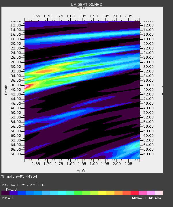
| Estimated Moho Depth: |
38.25 km |
| Estimated Crust Vp/Vs: |
1.60 |
| Assumed Crust Vp: |
6.353 km/s |
| Estimated Crust Vs: |
3.971 km/s |
| Estimated Crust Poisson's Ratio: |
0.18 |
|
| Radial Match: |
95.44354 % |
| Radial Bump: |
153 |
| Transverse Match: |
78.56489 % |
| Transverse Bump: |
400 |
| SOD ConfigId: |
2973751 |
| Insert Time: |
2018-10-08 22:08:17.000 +0000 |
| GWidth: |
2.5 |
| Max Bumps: |
400 |
| Tol: |
0.001 |
|

Signal To Noise
| Channel | StoN | STA | LTA |
| UM:GBMT:00:HHZ:20170908T04:55:39.249996Z | 8.747505 | 8.066053E-6 | 9.2209757E-7 |
| UM:GBMT:00:HHN:20170908T04:55:39.249996Z | 3.7856786 | 4.144095E-6 | 1.0946768E-6 |
| UM:GBMT:00:HHE:20170908T04:55:39.249996Z | 3.2180026 | 3.0159354E-6 | 9.3720723E-7 |
| Arrivals |
| Ps | 3.9 SECOND |
| PpPs | 14 SECOND |
| PsPs/PpSs | 18 SECOND |


