You are here: Home > Network List > UM - University of Montana - Missoula Stations List
> Station LGMT Long Gulch > Earthquake Result Viewer
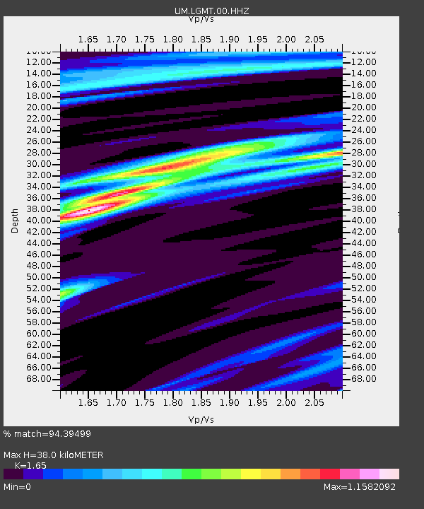
LGMT Long Gulch - Earthquake Result Viewer
| Earthquake location: |
Near Coast Of Chiapas, Mexico |
| Earthquake latitude/longitude: |
15.1/-93.7 |
| Earthquake time(UTC): |
2017/09/08 (251) 04:49:21 GMT |
| Earthquake Depth: |
70 km |
| Earthquake Magnitude: |
8.1 Mww |
| Earthquake Catalog/Contributor: |
NEIC PDE/us |
|
| Network: |
UM University of Montana - Missoula |
| Station: |
LGMT Long Gulch |
| Lat/Lon: |
46.88 N/112.61 W |
| Elevation: |
1784 m |
|
| Distance: |
35.4 deg |
| Az: |
337.467 deg |
| Baz: |
147.337 deg |
| Ray Param: |
0.07703244 |
| Estimated Moho Depth: |
38.0 km |
| Estimated Crust Vp/Vs: |
1.65 |
| Assumed Crust Vp: |
6.353 km/s |
| Estimated Crust Vs: |
3.85 km/s |
| Estimated Crust Poisson's Ratio: |
0.21 |
|
| Radial Match: |
94.39499 % |
| Radial Bump: |
210 |
| Transverse Match: |
63.249077 % |
| Transverse Bump: |
400 |
| SOD ConfigId: |
2973751 |
| Insert Time: |
2018-10-08 22:08:18.304 +0000 |
| GWidth: |
2.5 |
| Max Bumps: |
400 |
| Tol: |
0.001 |
|

Signal To Noise
| Channel | StoN | STA | LTA |
| UM:LGMT:00:HHZ:20170908T04:55:39.880001Z | 8.354354 | 7.5747603E-6 | 9.066842E-7 |
| UM:LGMT:00:HHN:20170908T04:55:39.880001Z | 3.4679213 | 4.2396705E-6 | 1.2225394E-6 |
| UM:LGMT:00:HHE:20170908T04:55:39.880001Z | 2.9612803 | 2.4906778E-6 | 8.410814E-7 |
| Arrivals |
| Ps | 4.2 SECOND |
| PpPs | 15 SECOND |
| PsPs/PpSs | 19 SECOND |


