You are here: Home > Network List > TA - USArray Transportable Network (new EarthScope stations) Stations List
> Station J22A Midwest, WY, USA > Earthquake Result Viewer
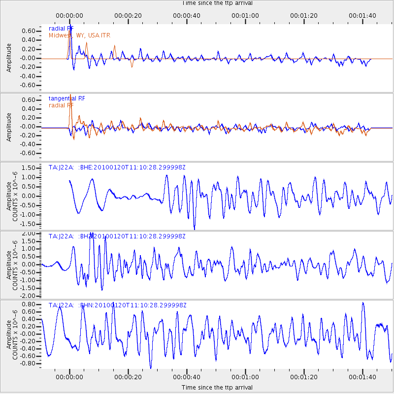
J22A Midwest, WY, USA - Earthquake Result Viewer
*The percent match for this event was below the threshold and hence no stack was calculated.
| Earthquake location: |
Haiti Region |
| Earthquake latitude/longitude: |
18.4/-72.8 |
| Earthquake time(UTC): |
2010/01/20 (020) 11:03:43 GMT |
| Earthquake Depth: |
10 km |
| Earthquake Magnitude: |
5.9 MB, 5.8 MS, 5.9 MW, 5.9 MW |
| Earthquake Catalog/Contributor: |
WHDF/NEIC |
|
| Network: |
TA USArray Transportable Network (new EarthScope stations) |
| Station: |
J22A Midwest, WY, USA |
| Lat/Lon: |
43.41 N/106.48 W |
| Elevation: |
1587 m |
|
| Distance: |
37.7 deg |
| Az: |
318.694 deg |
| Baz: |
120.689 deg |
| Ray Param: |
$rayparam |
*The percent match for this event was below the threshold and hence was not used in the summary stack. |
|
| Radial Match: |
67.43696 % |
| Radial Bump: |
329 |
| Transverse Match: |
61.069534 % |
| Transverse Bump: |
341 |
| SOD ConfigId: |
296938 |
| Insert Time: |
2010-04-06 22:22:57.279 +0000 |
| GWidth: |
2.5 |
| Max Bumps: |
400 |
| Tol: |
0.001 |
|
Signal To Noise
| Channel | StoN | STA | LTA |
| TA:J22A: :BHZ:20100120T11:10:28.299998Z | 1.9164588 | 7.098102E-7 | 3.7037591E-7 |
| TA:J22A: :BHN:20100120T11:10:28.299998Z | 1.2759782 | 3.689877E-7 | 2.8918026E-7 |
| TA:J22A: :BHE:20100120T11:10:28.299998Z | 1.2935541 | 5.4278723E-7 | 4.1960922E-7 |
| Arrivals |
| Ps | |
| PpPs | |
| PsPs/PpSs | |


