You are here: Home > Network List > TA - USArray Transportable Network (new EarthScope stations) Stations List
> Station P29A Atwood, KS, USA > Earthquake Result Viewer
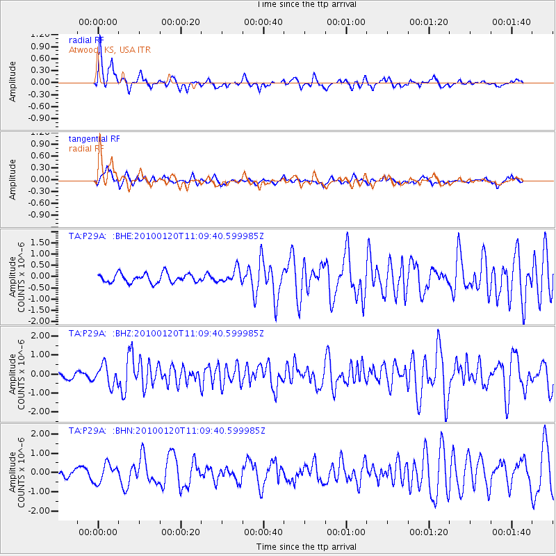
P29A Atwood, KS, USA - Earthquake Result Viewer
*The percent match for this event was below the threshold and hence no stack was calculated.
| Earthquake location: |
Haiti Region |
| Earthquake latitude/longitude: |
18.4/-72.8 |
| Earthquake time(UTC): |
2010/01/20 (020) 11:03:43 GMT |
| Earthquake Depth: |
10 km |
| Earthquake Magnitude: |
5.9 MB, 5.8 MS, 5.9 MW, 5.9 MW |
| Earthquake Catalog/Contributor: |
WHDF/NEIC |
|
| Network: |
TA USArray Transportable Network (new EarthScope stations) |
| Station: |
P29A Atwood, KS, USA |
| Lat/Lon: |
39.60 N/100.93 W |
| Elevation: |
929 m |
|
| Distance: |
32.2 deg |
| Az: |
316.88 deg |
| Baz: |
122.866 deg |
| Ray Param: |
$rayparam |
*The percent match for this event was below the threshold and hence was not used in the summary stack. |
|
| Radial Match: |
78.08539 % |
| Radial Bump: |
383 |
| Transverse Match: |
49.456383 % |
| Transverse Bump: |
395 |
| SOD ConfigId: |
296938 |
| Insert Time: |
2010-04-06 22:26:51.651 +0000 |
| GWidth: |
2.5 |
| Max Bumps: |
400 |
| Tol: |
0.001 |
|
Signal To Noise
| Channel | StoN | STA | LTA |
| TA:P29A: :BHZ:20100120T11:09:40.599985Z | 3.602569 | 5.3691815E-7 | 1.4903758E-7 |
| TA:P29A: :BHN:20100120T11:09:40.599985Z | 1.681837 | 4.7885203E-7 | 2.8471965E-7 |
| TA:P29A: :BHE:20100120T11:09:40.599985Z | 1.5501738 | 3.1159377E-7 | 2.0100572E-7 |
| Arrivals |
| Ps | |
| PpPs | |
| PsPs/PpSs | |


