You are here: Home > Network List > AV - Alaska Volcano Observatory Stations List
> Station KIMD MID Benchmark, Kanaga Volcano, Alaska > Earthquake Result Viewer
KIMD MID Benchmark, Kanaga Volcano, Alaska - Earthquake Result Viewer
| Earthquake location: |
Tonga Islands Region |
| Earthquake latitude/longitude: |
-19.3/-172.1 |
| Earthquake time(UTC): |
2022/11/11 (315) 10:48:45 GMT |
| Earthquake Depth: |
25 km |
| Earthquake Magnitude: |
7.3 Mww |
| Earthquake Catalog/Contributor: |
NEIC PDE/us |
|
| Network: |
AV Alaska Volcano Observatory |
| Station: |
KIMD MID Benchmark, Kanaga Volcano, Alaska |
| Lat/Lon: |
51.76 N/177.24 W |
| Elevation: |
183 m |
|
| Distance: |
70.9 deg |
| Az: |
356.624 deg |
| Baz: |
174.867 deg |
| Ray Param: |
0.0546418 |
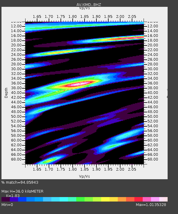
| Estimated Moho Depth: |
36.0 km |
| Estimated Crust Vp/Vs: |
1.83 |
| Assumed Crust Vp: |
5.88 km/s |
| Estimated Crust Vs: |
3.213 km/s |
| Estimated Crust Poisson's Ratio: |
0.29 |
|
| Radial Match: |
94.85943 % |
| Radial Bump: |
400 |
| Transverse Match: |
93.265144 % |
| Transverse Bump: |
400 |
| SOD ConfigId: |
29823551 |
| Insert Time: |
2022-11-28 00:03:19.910 +0000 |
| GWidth: |
2.5 |
| Max Bumps: |
400 |
| Tol: |
0.001 |
|

Signal To Noise
| Channel | StoN | STA | LTA |
| AV:KIMD: :BHZ:20221111T10:59:28.979014Z | 3.7636378 | 1.1914391E-5 | 3.1656582E-6 |
| AV:KIMD: :BHN:20221111T10:59:28.979014Z | 3.6765935 | 7.3723663E-6 | 2.0052166E-6 |
| AV:KIMD: :BHE:20221111T10:59:28.979014Z | 0.81188285 | 1.8902955E-6 | 2.328286E-6 |
| Arrivals |
| Ps | 5.2 SECOND |
| PpPs | 17 SECOND |
| PsPs/PpSs | 22 SECOND |


