You are here: Home > Network List > AV - Alaska Volcano Observatory Stations List
> Station KOSE Southeast, Korovin Volcano, Alaska > Earthquake Result Viewer
KOSE Southeast, Korovin Volcano, Alaska - Earthquake Result Viewer
| Earthquake location: |
Tonga Islands Region |
| Earthquake latitude/longitude: |
-19.3/-172.1 |
| Earthquake time(UTC): |
2022/11/11 (315) 10:48:45 GMT |
| Earthquake Depth: |
25 km |
| Earthquake Magnitude: |
7.3 Mww |
| Earthquake Catalog/Contributor: |
NEIC PDE/us |
|
| Network: |
AV Alaska Volcano Observatory |
| Station: |
KOSE Southeast, Korovin Volcano, Alaska |
| Lat/Lon: |
52.34 N/174.05 W |
| Elevation: |
625 m |
|
| Distance: |
71.4 deg |
| Az: |
358.737 deg |
| Baz: |
178.056 deg |
| Ray Param: |
0.05434616 |
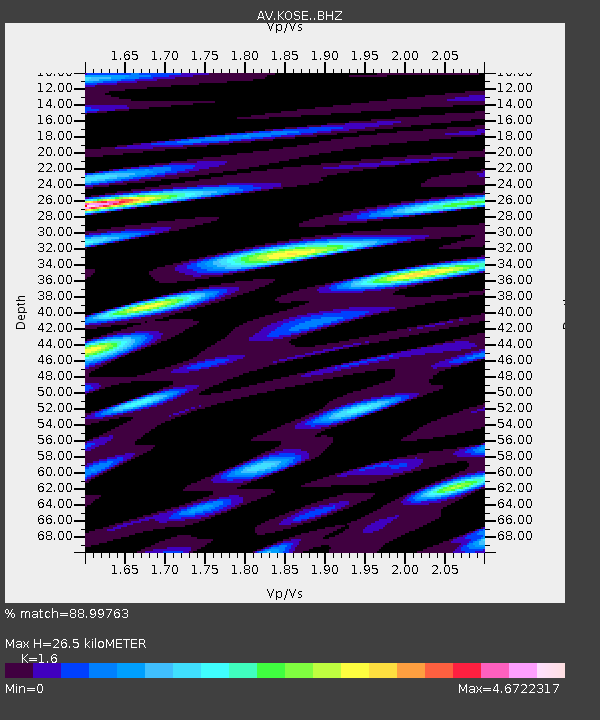
| Estimated Moho Depth: |
26.5 km |
| Estimated Crust Vp/Vs: |
1.60 |
| Assumed Crust Vp: |
5.88 km/s |
| Estimated Crust Vs: |
3.675 km/s |
| Estimated Crust Poisson's Ratio: |
0.18 |
|
| Radial Match: |
88.99763 % |
| Radial Bump: |
400 |
| Transverse Match: |
86.05292 % |
| Transverse Bump: |
400 |
| SOD ConfigId: |
29823551 |
| Insert Time: |
2022-11-28 00:03:34.045 +0000 |
| GWidth: |
2.5 |
| Max Bumps: |
400 |
| Tol: |
0.001 |
|

Signal To Noise
| Channel | StoN | STA | LTA |
| AV:KOSE: :BHZ:20221111T10:59:31.758982Z | 6.906902 | 1.9303854E-5 | 2.7948643E-6 |
| AV:KOSE: :BHN:20221111T10:59:31.758982Z | 1.873146 | 1.2276281E-5 | 6.55383E-6 |
| AV:KOSE: :BHE:20221111T10:59:31.758982Z | 2.1363056 | 1.1494849E-5 | 5.380714E-6 |
| Arrivals |
| Ps | 2.8 SECOND |
| PpPs | 11 SECOND |
| PsPs/PpSs | 14 SECOND |


