You are here: Home > Network List > TA - USArray Transportable Network (new EarthScope stations) Stations List
> Station P31A Stockton, KS, USA > Earthquake Result Viewer
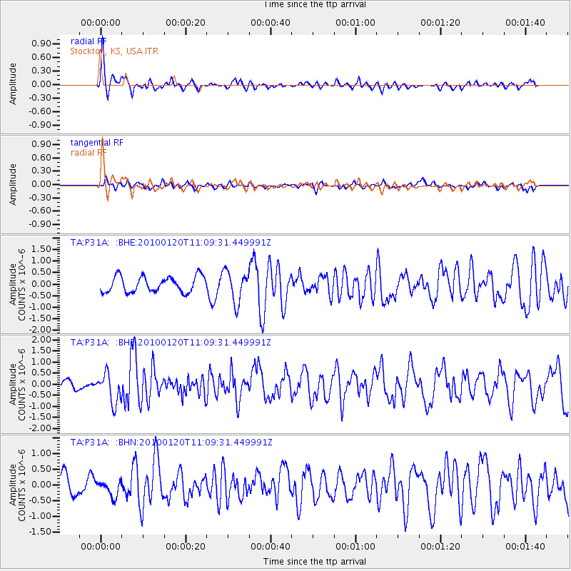
P31A Stockton, KS, USA - Earthquake Result Viewer
*The percent match for this event was below the threshold and hence no stack was calculated.
| Earthquake location: |
Haiti Region |
| Earthquake latitude/longitude: |
18.4/-72.8 |
| Earthquake time(UTC): |
2010/01/20 (020) 11:03:43 GMT |
| Earthquake Depth: |
10 km |
| Earthquake Magnitude: |
5.9 MB, 5.8 MS, 5.9 MW, 5.9 MW |
| Earthquake Catalog/Contributor: |
WHDF/NEIC |
|
| Network: |
TA USArray Transportable Network (new EarthScope stations) |
| Station: |
P31A Stockton, KS, USA |
| Lat/Lon: |
39.52 N/99.38 W |
| Elevation: |
665 m |
|
| Distance: |
31.1 deg |
| Az: |
318.026 deg |
| Baz: |
124.827 deg |
| Ray Param: |
$rayparam |
*The percent match for this event was below the threshold and hence was not used in the summary stack. |
|
| Radial Match: |
72.99775 % |
| Radial Bump: |
356 |
| Transverse Match: |
52.2415 % |
| Transverse Bump: |
400 |
| SOD ConfigId: |
296938 |
| Insert Time: |
2010-04-06 22:27:18.413 +0000 |
| GWidth: |
2.5 |
| Max Bumps: |
400 |
| Tol: |
0.001 |
|
Signal To Noise
| Channel | StoN | STA | LTA |
| TA:P31A: :BHZ:20100120T11:09:31.449991Z | 4.886383 | 6.8222556E-7 | 1.396177E-7 |
| TA:P31A: :BHN:20100120T11:09:31.449991Z | 1.0983709 | 2.5380382E-7 | 2.3107296E-7 |
| TA:P31A: :BHE:20100120T11:09:31.449991Z | 2.0140324 | 6.809075E-7 | 3.380817E-7 |
| Arrivals |
| Ps | |
| PpPs | |
| PsPs/PpSs | |


