You are here: Home > Network List > AV - Alaska Volcano Observatory Stations List
> Station MTBL Table Top, Makushin Volcano, Alaska > Earthquake Result Viewer
MTBL Table Top, Makushin Volcano, Alaska - Earthquake Result Viewer
| Earthquake location: |
Tonga Islands Region |
| Earthquake latitude/longitude: |
-19.3/-172.1 |
| Earthquake time(UTC): |
2022/11/11 (315) 10:48:45 GMT |
| Earthquake Depth: |
25 km |
| Earthquake Magnitude: |
7.3 Mww |
| Earthquake Catalog/Contributor: |
NEIC PDE/us |
|
| Network: |
AV Alaska Volcano Observatory |
| Station: |
MTBL Table Top, Makushin Volcano, Alaska |
| Lat/Lon: |
53.97 N/166.68 W |
| Elevation: |
810 m |
|
| Distance: |
73.1 deg |
| Az: |
3.342 deg |
| Baz: |
185.347 deg |
| Ray Param: |
0.053179678 |
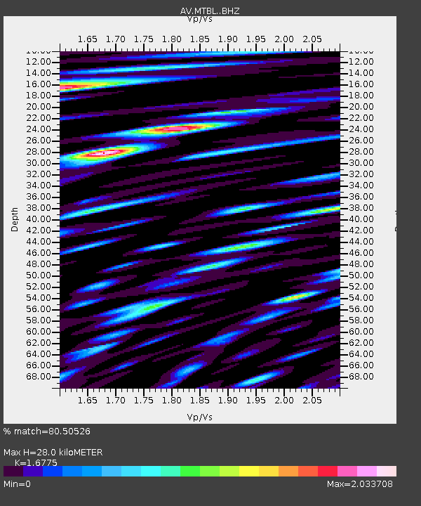
| Estimated Moho Depth: |
28.0 km |
| Estimated Crust Vp/Vs: |
1.68 |
| Assumed Crust Vp: |
3.943 km/s |
| Estimated Crust Vs: |
2.351 km/s |
| Estimated Crust Poisson's Ratio: |
0.22 |
|
| Radial Match: |
80.50526 % |
| Radial Bump: |
400 |
| Transverse Match: |
88.97724 % |
| Transverse Bump: |
400 |
| SOD ConfigId: |
29823551 |
| Insert Time: |
2022-11-28 00:03:51.241 +0000 |
| GWidth: |
2.5 |
| Max Bumps: |
400 |
| Tol: |
0.001 |
|

Signal To Noise
| Channel | StoN | STA | LTA |
| AV:MTBL: :BHZ:20221111T10:59:42.219981Z | 5.5994954 | 1.1690357E-5 | 2.0877517E-6 |
| AV:MTBL: :BHN:20221111T10:59:42.219981Z | 2.852111 | 7.0545652E-6 | 2.4734538E-6 |
| AV:MTBL: :BHE:20221111T10:59:42.219981Z | 2.9111328 | 9.2828595E-6 | 3.1887448E-6 |
| Arrivals |
| Ps | 4.9 SECOND |
| PpPs | 19 SECOND |
| PsPs/PpSs | 24 SECOND |


