You are here: Home > Network List > AV - Alaska Volcano Observatory Stations List
> Station SSLS South, Shishaldin Volcano, Alaska > Earthquake Result Viewer
SSLS South, Shishaldin Volcano, Alaska - Earthquake Result Viewer
| Earthquake location: |
Tonga Islands Region |
| Earthquake latitude/longitude: |
-19.3/-172.1 |
| Earthquake time(UTC): |
2022/11/11 (315) 10:48:45 GMT |
| Earthquake Depth: |
25 km |
| Earthquake Magnitude: |
7.3 Mww |
| Earthquake Catalog/Contributor: |
NEIC PDE/us |
|
| Network: |
AV Alaska Volcano Observatory |
| Station: |
SSLS South, Shishaldin Volcano, Alaska |
| Lat/Lon: |
54.71 N/164.00 W |
| Elevation: |
817 m |
|
| Distance: |
74.1 deg |
| Az: |
4.878 deg |
| Baz: |
187.954 deg |
| Ray Param: |
0.05257547 |
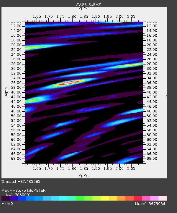
| Estimated Moho Depth: |
35.75 km |
| Estimated Crust Vp/Vs: |
1.79 |
| Assumed Crust Vp: |
5.989 km/s |
| Estimated Crust Vs: |
3.355 km/s |
| Estimated Crust Poisson's Ratio: |
0.27 |
|
| Radial Match: |
87.485565 % |
| Radial Bump: |
400 |
| Transverse Match: |
83.65366 % |
| Transverse Bump: |
400 |
| SOD ConfigId: |
29823551 |
| Insert Time: |
2022-11-28 00:04:25.470 +0000 |
| GWidth: |
2.5 |
| Max Bumps: |
400 |
| Tol: |
0.001 |
|

Signal To Noise
| Channel | StoN | STA | LTA |
| AV:SSLS: :BHZ:20221111T10:59:47.599009Z | 3.993169 | 1.2559268E-5 | 3.1451882E-6 |
| AV:SSLS: :BHN:20221111T10:59:47.599009Z | 1.6474141 | 7.997332E-6 | 4.8544766E-6 |
| AV:SSLS: :BHE:20221111T10:59:47.599009Z | 0.8890856 | 6.0701864E-6 | 6.827449E-6 |
| Arrivals |
| Ps | 4.8 SECOND |
| PpPs | 16 SECOND |
| PsPs/PpSs | 21 SECOND |


