You are here: Home > Network List > AV - Alaska Volcano Observatory Stations List
> Station WESE Southeast, Westdahl Peak, Alaska > Earthquake Result Viewer
WESE Southeast, Westdahl Peak, Alaska - Earthquake Result Viewer
| Earthquake location: |
Tonga Islands Region |
| Earthquake latitude/longitude: |
-19.3/-172.1 |
| Earthquake time(UTC): |
2022/11/11 (315) 10:48:45 GMT |
| Earthquake Depth: |
25 km |
| Earthquake Magnitude: |
7.3 Mww |
| Earthquake Catalog/Contributor: |
NEIC PDE/us |
|
| Network: |
AV Alaska Volcano Observatory |
| Station: |
WESE Southeast, Westdahl Peak, Alaska |
| Lat/Lon: |
54.47 N/164.59 W |
| Elevation: |
953 m |
|
| Distance: |
73.8 deg |
| Az: |
4.56 deg |
| Baz: |
187.39 deg |
| Ray Param: |
0.052760754 |
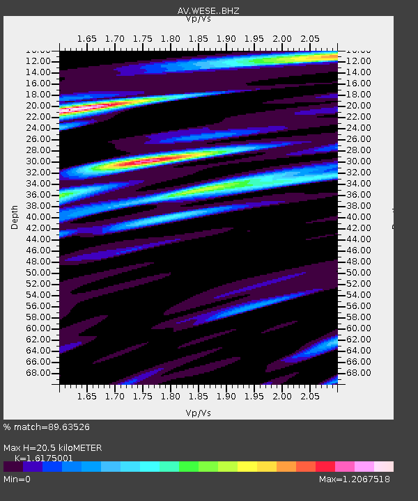
| Estimated Moho Depth: |
20.5 km |
| Estimated Crust Vp/Vs: |
1.62 |
| Assumed Crust Vp: |
5.989 km/s |
| Estimated Crust Vs: |
3.703 km/s |
| Estimated Crust Poisson's Ratio: |
0.19 |
|
| Radial Match: |
89.63526 % |
| Radial Bump: |
400 |
| Transverse Match: |
86.671974 % |
| Transverse Bump: |
400 |
| SOD ConfigId: |
29823551 |
| Insert Time: |
2022-11-28 00:04:45.019 +0000 |
| GWidth: |
2.5 |
| Max Bumps: |
400 |
| Tol: |
0.001 |
|

Signal To Noise
| Channel | StoN | STA | LTA |
| AV:WESE: :BHZ:20221111T10:59:45.958995Z | 6.388328 | 1.6042251E-5 | 2.5111815E-6 |
| AV:WESE: :BHN:20221111T10:59:45.958995Z | 2.1747859 | 1.2177304E-5 | 5.599312E-6 |
| AV:WESE: :BHE:20221111T10:59:45.958995Z | 2.1509287 | 5.951565E-6 | 2.7669746E-6 |
| Arrivals |
| Ps | 2.2 SECOND |
| PpPs | 8.7 SECOND |
| PsPs/PpSs | 11 SECOND |


