You are here: Home > Network List > O2 - Oklahoma Consolidated Temporary Seismic Networks Stations List
> Station SC10 Scott, Oklahoma, USA > Earthquake Result Viewer
SC10 Scott, Oklahoma, USA - Earthquake Result Viewer
| Earthquake location: |
Tonga Islands Region |
| Earthquake latitude/longitude: |
-19.3/-172.1 |
| Earthquake time(UTC): |
2022/11/11 (315) 10:48:45 GMT |
| Earthquake Depth: |
25 km |
| Earthquake Magnitude: |
7.3 Mww |
| Earthquake Catalog/Contributor: |
NEIC PDE/us |
|
| Network: |
O2 Oklahoma Consolidated Temporary Seismic Networks |
| Station: |
SC10 Scott, Oklahoma, USA |
| Lat/Lon: |
35.42 N/98.27 W |
| Elevation: |
502 m |
|
| Distance: |
88.6 deg |
| Az: |
51.69 deg |
| Baz: |
245.136 deg |
| Ray Param: |
0.042467598 |
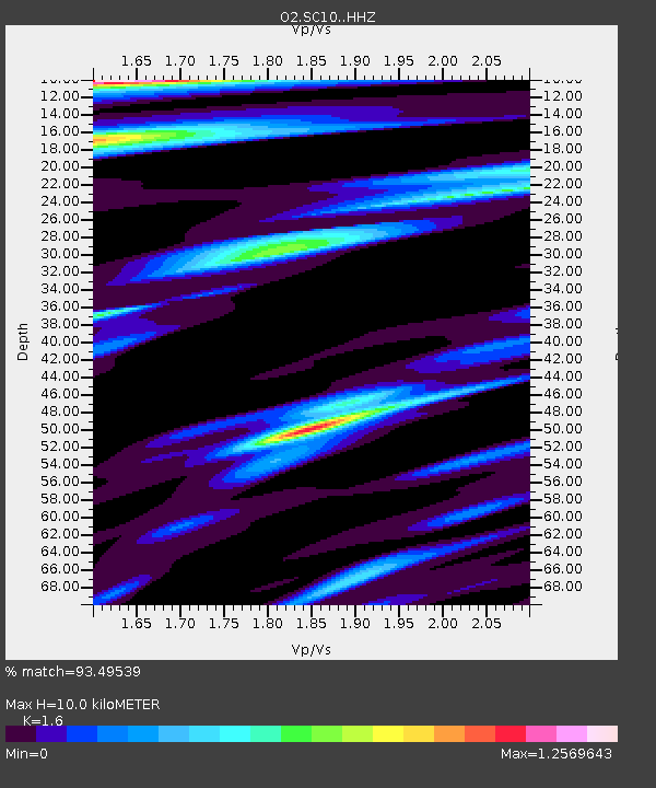
| Estimated Moho Depth: |
10.0 km |
| Estimated Crust Vp/Vs: |
1.60 |
| Assumed Crust Vp: |
6.315 km/s |
| Estimated Crust Vs: |
3.947 km/s |
| Estimated Crust Poisson's Ratio: |
0.18 |
|
| Radial Match: |
93.49539 % |
| Radial Bump: |
290 |
| Transverse Match: |
90.1257 % |
| Transverse Bump: |
374 |
| SOD ConfigId: |
29823551 |
| Insert Time: |
2022-11-28 00:11:10.331 +0000 |
| GWidth: |
2.5 |
| Max Bumps: |
400 |
| Tol: |
0.001 |
|

Signal To Noise
| Channel | StoN | STA | LTA |
| O2:SC10: :HHZ:20221111T11:01:04.214976Z | 18.365595 | 8.685587E-6 | 4.729271E-7 |
| O2:SC10: :HHN:20221111T11:01:04.214976Z | 1.6220027 | 8.133395E-7 | 5.014415E-7 |
| O2:SC10: :HHE:20221111T11:01:04.214976Z | 3.1717834 | 1.6064396E-6 | 5.0647833E-7 |
| Arrivals |
| Ps | 1.0 SECOND |
| PpPs | 4.0 SECOND |
| PsPs/PpSs | 5.0 SECOND |


