You are here: Home > Network List > TM - Thai Seismic Monitoring Network Stations List
> Station SURA Don Sak, Surat Thani > Earthquake Result Viewer
SURA Don Sak, Surat Thani - Earthquake Result Viewer
| Earthquake location: |
Tonga Islands Region |
| Earthquake latitude/longitude: |
-19.3/-172.1 |
| Earthquake time(UTC): |
2022/11/11 (315) 10:48:45 GMT |
| Earthquake Depth: |
25 km |
| Earthquake Magnitude: |
7.3 Mww |
| Earthquake Catalog/Contributor: |
NEIC PDE/us |
|
| Network: |
TM Thai Seismic Monitoring Network |
| Station: |
SURA Don Sak, Surat Thani |
| Lat/Lon: |
9.17 N/99.63 E |
| Elevation: |
18 m |
|
| Distance: |
91.4 deg |
| Az: |
279.167 deg |
| Baz: |
109.226 deg |
| Ray Param: |
0.041611563 |
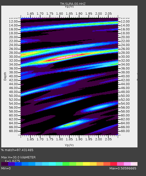
| Estimated Moho Depth: |
30.0 km |
| Estimated Crust Vp/Vs: |
1.83 |
| Assumed Crust Vp: |
6.468 km/s |
| Estimated Crust Vs: |
3.539 km/s |
| Estimated Crust Poisson's Ratio: |
0.29 |
|
| Radial Match: |
97.431465 % |
| Radial Bump: |
400 |
| Transverse Match: |
90.88606 % |
| Transverse Bump: |
400 |
| SOD ConfigId: |
29823551 |
| Insert Time: |
2022-11-28 00:13:37.173 +0000 |
| GWidth: |
2.5 |
| Max Bumps: |
400 |
| Tol: |
0.001 |
|

Signal To Noise
| Channel | StoN | STA | LTA |
| TM:SURA:00:HHZ:20221111T11:01:17.25001Z | 30.5575 | 2.969864E-6 | 9.7189364E-8 |
| TM:SURA:00:HHN:20221111T11:01:17.25001Z | 1.0305322 | 4.939439E-7 | 4.793095E-7 |
| TM:SURA:00:HHE:20221111T11:01:17.25001Z | 2.2934558 | 8.3759727E-7 | 3.652119E-7 |
| Arrivals |
| Ps | 3.9 SECOND |
| PpPs | 13 SECOND |
| PsPs/PpSs | 17 SECOND |


