You are here: Home > Network List > TA - USArray Transportable Network (new EarthScope stations) Stations List
> Station P32A Huiting Farm, Downs, KS, USA > Earthquake Result Viewer
P32A Huiting Farm, Downs, KS, USA - Earthquake Result Viewer
| Earthquake location: |
Haiti Region |
| Earthquake latitude/longitude: |
18.4/-72.8 |
| Earthquake time(UTC): |
2010/01/20 (020) 11:03:43 GMT |
| Earthquake Depth: |
10 km |
| Earthquake Magnitude: |
5.9 MB, 5.8 MS, 5.9 MW, 5.9 MW |
| Earthquake Catalog/Contributor: |
WHDF/NEIC |
|
| Network: |
TA USArray Transportable Network (new EarthScope stations) |
| Station: |
P32A Huiting Farm, Downs, KS, USA |
| Lat/Lon: |
39.62 N/98.60 W |
| Elevation: |
524 m |
|
| Distance: |
30.7 deg |
| Az: |
318.864 deg |
| Baz: |
126.039 deg |
| Ray Param: |
0.07926174 |
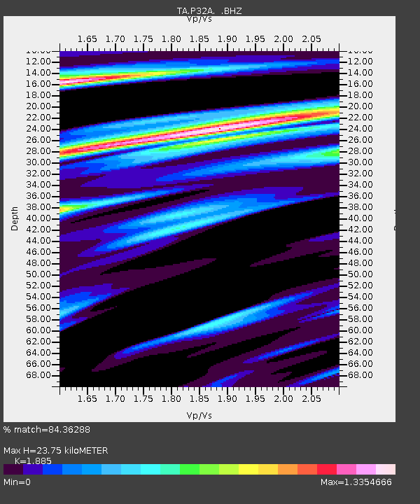
| Estimated Moho Depth: |
23.75 km |
| Estimated Crust Vp/Vs: |
1.88 |
| Assumed Crust Vp: |
6.483 km/s |
| Estimated Crust Vs: |
3.439 km/s |
| Estimated Crust Poisson's Ratio: |
0.30 |
|
| Radial Match: |
84.36288 % |
| Radial Bump: |
383 |
| Transverse Match: |
56.351913 % |
| Transverse Bump: |
400 |
| SOD ConfigId: |
296938 |
| Insert Time: |
2010-04-06 22:30:15.347 +0000 |
| GWidth: |
2.5 |
| Max Bumps: |
400 |
| Tol: |
0.001 |
|
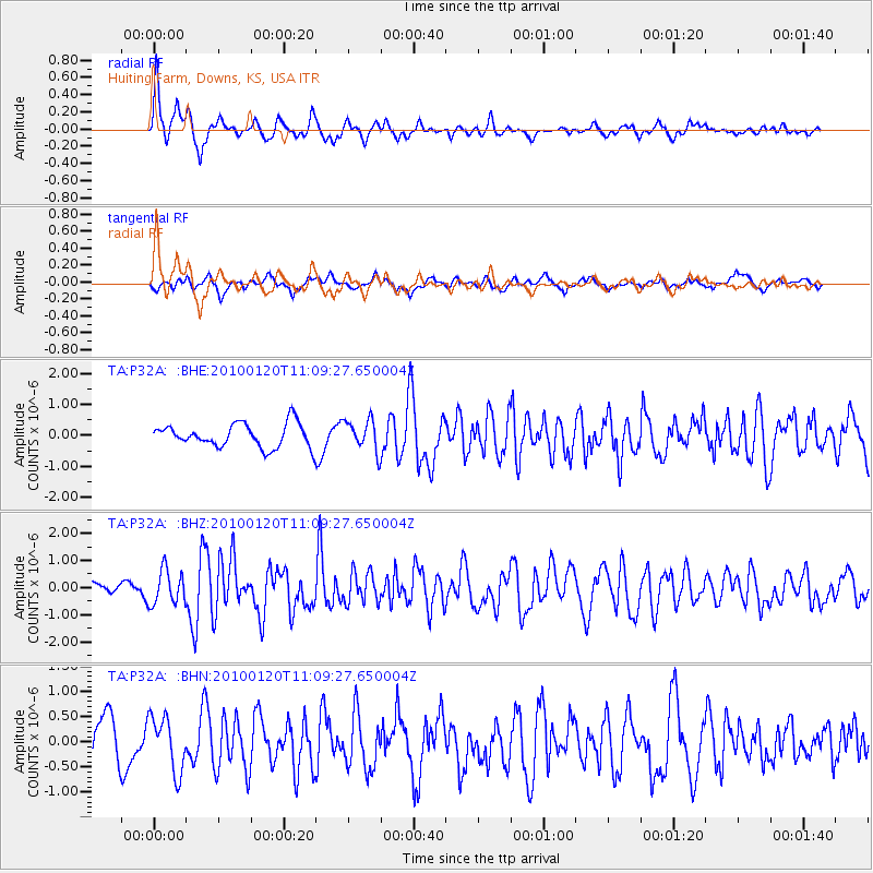
Signal To Noise
| Channel | StoN | STA | LTA |
| TA:P32A: :BHZ:20100120T11:09:27.650004Z | 2.0626771 | 6.2679754E-7 | 3.0387574E-7 |
| TA:P32A: :BHN:20100120T11:09:27.650004Z | 1.0669115 | 5.4583586E-7 | 5.116037E-7 |
| TA:P32A: :BHE:20100120T11:09:27.650004Z | 1.3381705 | 5.043103E-7 | 3.7686553E-7 |
| Arrivals |
| Ps | 3.5 SECOND |
| PpPs | 9.8 SECOND |
| PsPs/PpSs | 13 SECOND |


