You are here: Home > Network List > US - United States National Seismic Network Stations List
> Station HLID Hailey, Idaho, USA > Earthquake Result Viewer
HLID Hailey, Idaho, USA - Earthquake Result Viewer
*The percent match for this event was below the threshold and hence no stack was calculated.
| Earthquake location: |
Haiti Region |
| Earthquake latitude/longitude: |
18.4/-72.8 |
| Earthquake time(UTC): |
2010/01/20 (020) 11:03:43 GMT |
| Earthquake Depth: |
10 km |
| Earthquake Magnitude: |
5.9 MB, 5.8 MS, 5.9 MW, 5.9 MW |
| Earthquake Catalog/Contributor: |
WHDF/NEIC |
|
| Network: |
US United States National Seismic Network |
| Station: |
HLID Hailey, Idaho, USA |
| Lat/Lon: |
43.56 N/114.41 W |
| Elevation: |
1772 m |
|
| Distance: |
43.0 deg |
| Az: |
314.919 deg |
| Baz: |
112.361 deg |
| Ray Param: |
$rayparam |
*The percent match for this event was below the threshold and hence was not used in the summary stack. |
|
| Radial Match: |
69.293564 % |
| Radial Bump: |
390 |
| Transverse Match: |
70.2503 % |
| Transverse Bump: |
362 |
| SOD ConfigId: |
296938 |
| Insert Time: |
2010-04-06 22:30:47.775 +0000 |
| GWidth: |
2.5 |
| Max Bumps: |
400 |
| Tol: |
0.001 |
|
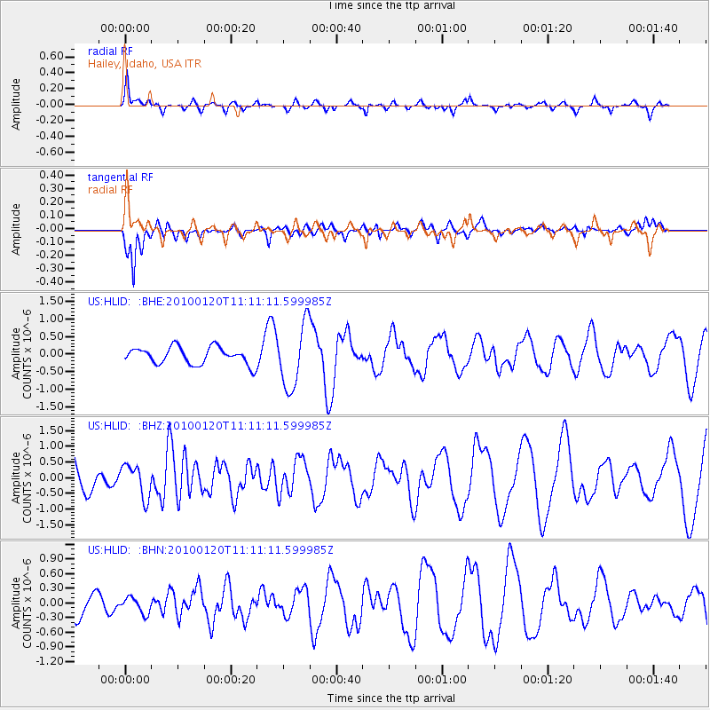
Signal To Noise
| Channel | StoN | STA | LTA |
| US:HLID: :BHZ:20100120T11:11:11.599985Z | 0.82527965 | 5.2299697E-7 | 6.337209E-7 |
| US:HLID: :BHN:20100120T11:11:11.599985Z | 0.42987743 | 1.6373762E-7 | 3.8089374E-7 |
| US:HLID: :BHE:20100120T11:11:11.599985Z | 3.7711136 | 9.084509E-7 | 2.4089724E-7 |
| Arrivals |
| Ps | |
| PpPs | |
| PsPs/PpSs | |


