You are here: Home > Network List > US - United States National Seismic Network Stations List
> Station AGMN Agassiz National Wildlife Refuge, Minnesota, USA > Earthquake Result Viewer
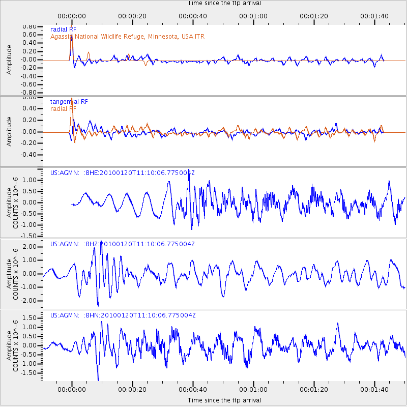
AGMN Agassiz National Wildlife Refuge, Minnesota, USA - Earthquake Result Viewer
*The percent match for this event was below the threshold and hence no stack was calculated.
| Earthquake location: |
Haiti Region |
| Earthquake latitude/longitude: |
18.4/-72.8 |
| Earthquake time(UTC): |
2010/01/20 (020) 11:03:43 GMT |
| Earthquake Depth: |
10 km |
| Earthquake Magnitude: |
5.9 MB, 5.8 MS, 5.9 MW, 5.9 MW |
| Earthquake Catalog/Contributor: |
WHDF/NEIC |
|
| Network: |
US United States National Seismic Network |
| Station: |
AGMN Agassiz National Wildlife Refuge, Minnesota, USA |
| Lat/Lon: |
48.30 N/95.86 W |
| Elevation: |
351 m |
|
| Distance: |
35.2 deg |
| Az: |
333.036 deg |
| Baz: |
139.859 deg |
| Ray Param: |
$rayparam |
*The percent match for this event was below the threshold and hence was not used in the summary stack. |
|
| Radial Match: |
62.53281 % |
| Radial Bump: |
400 |
| Transverse Match: |
60.077724 % |
| Transverse Bump: |
400 |
| SOD ConfigId: |
296938 |
| Insert Time: |
2010-04-06 22:31:19.960 +0000 |
| GWidth: |
2.5 |
| Max Bumps: |
400 |
| Tol: |
0.001 |
|
Signal To Noise
| Channel | StoN | STA | LTA |
| US:AGMN: :BHZ:20100120T11:10:06.775004Z | 1.9591461 | 7.768394E-7 | 3.9651937E-7 |
| US:AGMN: :BHN:20100120T11:10:06.775004Z | 1.4900831 | 2.613499E-7 | 1.7539284E-7 |
| US:AGMN: :BHE:20100120T11:10:06.775004Z | 2.079656 | 5.7387507E-7 | 2.7594712E-7 |
| Arrivals |
| Ps | |
| PpPs | |
| PsPs/PpSs | |


