You are here: Home > Network List > US - United States National Seismic Network Stations List
> Station AMTX Amarillo, Texas, USA > Earthquake Result Viewer
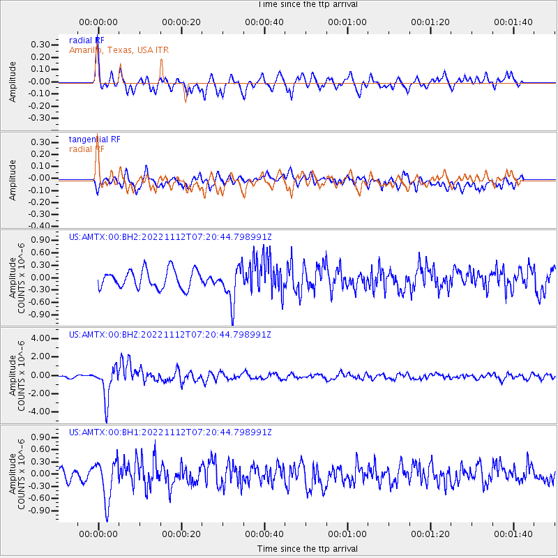
AMTX Amarillo, Texas, USA - Earthquake Result Viewer
*The percent match for this event was below the threshold and hence no stack was calculated.
| Earthquake location: |
Fiji Islands Region |
| Earthquake latitude/longitude: |
-20.1/-178.4 |
| Earthquake time(UTC): |
2022/11/12 (316) 07:09:14 GMT |
| Earthquake Depth: |
587 km |
| Earthquake Magnitude: |
7.0 mww |
| Earthquake Catalog/Contributor: |
NEIC PDE/us |
|
| Network: |
US United States National Seismic Network |
| Station: |
AMTX Amarillo, Texas, USA |
| Lat/Lon: |
34.53 N/101.41 W |
| Elevation: |
1010 m |
|
| Distance: |
91.0 deg |
| Az: |
53.554 deg |
| Baz: |
246.296 deg |
| Ray Param: |
$rayparam |
*The percent match for this event was below the threshold and hence was not used in the summary stack. |
|
| Radial Match: |
73.30636 % |
| Radial Bump: |
400 |
| Transverse Match: |
54.82445 % |
| Transverse Bump: |
400 |
| SOD ConfigId: |
29823551 |
| Insert Time: |
2022-11-28 01:03:19.123 +0000 |
| GWidth: |
2.5 |
| Max Bumps: |
400 |
| Tol: |
0.001 |
|
Signal To Noise
| Channel | StoN | STA | LTA |
| US:AMTX:00:BHZ:20221112T07:20:44.798991Z | 9.857349 | 1.8288189E-6 | 1.8552846E-7 |
| US:AMTX:00:BH1:20221112T07:20:44.798991Z | 3.7244313 | 5.0469464E-7 | 1.3550918E-7 |
| US:AMTX:00:BH2:20221112T07:20:44.798991Z | 2.0346928 | 4.4377362E-7 | 2.1810351E-7 |
| Arrivals |
| Ps | |
| PpPs | |
| PsPs/PpSs | |


