You are here: Home > Network List > US - United States National Seismic Network Stations List
> Station WRAK Wrangell Island, Southeastern Alaska, Alaska, USA > Earthquake Result Viewer
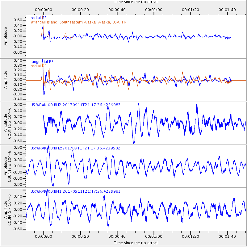
WRAK Wrangell Island, Southeastern Alaska, Alaska, USA - Earthquake Result Viewer
*The percent match for this event was below the threshold and hence no stack was calculated.
| Earthquake location: |
Near Coast Of Chiapas, Mexico |
| Earthquake latitude/longitude: |
14.9/-93.9 |
| Earthquake time(UTC): |
2017/09/11 (254) 21:09:10 GMT |
| Earthquake Depth: |
27 km |
| Earthquake Magnitude: |
5.5 Mww |
| Earthquake Catalog/Contributor: |
NEIC PDE/us |
|
| Network: |
US United States National Seismic Network |
| Station: |
WRAK Wrangell Island, Southeastern Alaska, Alaska, USA |
| Lat/Lon: |
56.42 N/132.35 W |
| Elevation: |
81 m |
|
| Distance: |
50.7 deg |
| Az: |
333.518 deg |
| Baz: |
129.109 deg |
| Ray Param: |
$rayparam |
*The percent match for this event was below the threshold and hence was not used in the summary stack. |
|
| Radial Match: |
48.020103 % |
| Radial Bump: |
400 |
| Transverse Match: |
51.416058 % |
| Transverse Bump: |
400 |
| SOD ConfigId: |
2973751 |
| Insert Time: |
2018-10-08 22:38:55.081 +0000 |
| GWidth: |
2.5 |
| Max Bumps: |
400 |
| Tol: |
0.001 |
|
Signal To Noise
| Channel | StoN | STA | LTA |
| US:WRAK:00:BHZ:20170911T21:17:36.423998Z | 2.5395489 | 5.4298795E-7 | 2.1381277E-7 |
| US:WRAK:00:BH1:20170911T21:17:36.423998Z | 1.6657575 | 3.5219094E-7 | 2.1142989E-7 |
| US:WRAK:00:BH2:20170911T21:17:36.423998Z | 1.7291666 | 2.9166299E-7 | 1.6867257E-7 |
| Arrivals |
| Ps | |
| PpPs | |
| PsPs/PpSs | |


