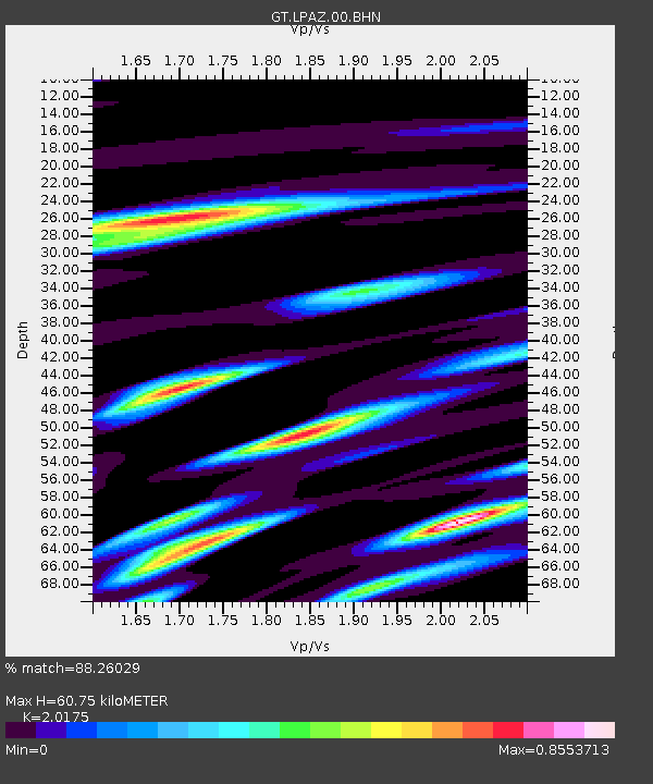
LPAZ La Paz , Bolivia - Earthquake Result Viewer
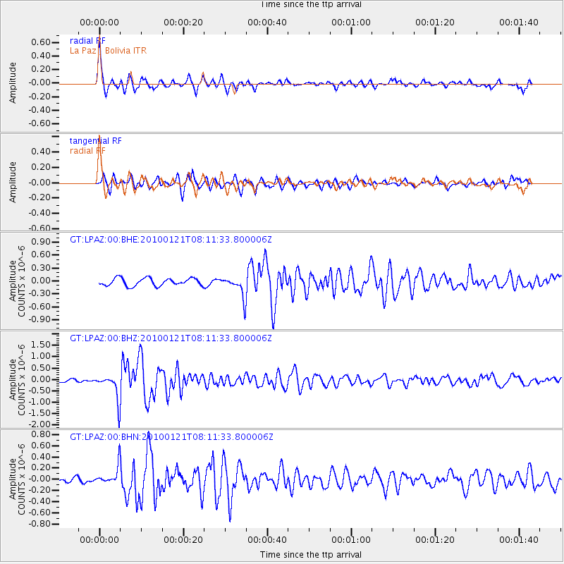
Earthquake location: East Central Pacific Ocean
Earthquake latitude/longitude: 8.3/-110.4
Earthquake time(UTC): 2010/01/21 (021) 08:03:22 GMT
Earthquake Depth: 10 km
Earthquake Magnitude: 5.8 MB, 5.3 MS, 5.6 MW, 5.6 MW
Earthquake Catalog/Contributor: WHDF/NEIC
Network: GT Global Telemetered Seismograph Network (USAF/USGS)
Station: LPAZ La Paz , Bolivia
Lat/Lon: 16.17 S/68.08 W
Elevation: 4817 m
Distance: 48.4 deg
Az: 120.15 deg
Baz: 297.044 deg
Ray Param: 0.069396466
Estimated Moho Depth: 60.75 km
Estimated Crust Vp/Vs: 2.02
Assumed Crust Vp: 6.454 km/s
Estimated Crust Vs: 3.199 km/s
Estimated Crust Poisson's Ratio: 0.34
Radial Match: 88.26029 %
Radial Bump: 400
Transverse Match: 77.6347 %
Transverse Bump: 400
SOD ConfigId: 296938
Insert Time: 2010-04-06 22:35:18.836 +0000
GWidth: 2.5
Max Bumps: 400
Tol: 0.001

Signal To Noise

ChannelStoNSTALTA
GT:LPAZ:00:BHZ:20100121T08:11:33.800006Z5.04681445.908785E-71.17079516E-7
GT:LPAZ:00:BHN:20100121T08:11:33.800006Z2.66795681.709793E-76.408624E-8
GT:LPAZ:00:BHE:20100121T08:11:33.800006Z2.7735272.4169677E-78.714419E-8
Arrivals
Ps10 SECOND
PpPs27 SECOND
PsPs/PpSs37 SECOND