You are here: Home > Network List > PE - Penn State Network Stations List
> Station PAGS PA Geological Survey > Earthquake Result Viewer
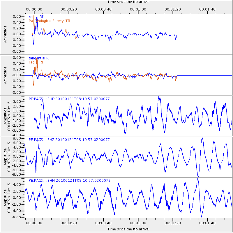
PAGS PA Geological Survey - Earthquake Result Viewer
*The percent match for this event was below the threshold and hence no stack was calculated.
| Earthquake location: |
East Central Pacific Ocean |
| Earthquake latitude/longitude: |
8.3/-110.4 |
| Earthquake time(UTC): |
2010/01/21 (021) 08:03:22 GMT |
| Earthquake Depth: |
10 km |
| Earthquake Magnitude: |
5.8 MB, 5.3 MS, 5.6 MW, 5.6 MW |
| Earthquake Catalog/Contributor: |
WHDF/NEIC |
|
| Network: |
PE Penn State Network |
| Station: |
PAGS PA Geological Survey |
| Lat/Lon: |
40.23 N/76.72 W |
| Elevation: |
120 m |
|
| Distance: |
43.7 deg |
| Az: |
37.855 deg |
| Baz: |
232.496 deg |
| Ray Param: |
$rayparam |
*The percent match for this event was below the threshold and hence was not used in the summary stack. |
|
| Radial Match: |
78.393524 % |
| Radial Bump: |
400 |
| Transverse Match: |
56.909573 % |
| Transverse Bump: |
400 |
| SOD ConfigId: |
296938 |
| Insert Time: |
2010-04-06 22:37:17.676 +0000 |
| GWidth: |
2.5 |
| Max Bumps: |
400 |
| Tol: |
0.001 |
|
Signal To Noise
| Channel | StoN | STA | LTA |
| PE:PAGS: :BHZ:20100121T08:10:57.020007Z | 1.5140254 | 3.6760703E-6 | 2.4280107E-6 |
| PE:PAGS: :BHN:20100121T08:10:57.020007Z | 1.8262308 | 2.5328486E-6 | 1.3869269E-6 |
| PE:PAGS: :BHE:20100121T08:10:57.020007Z | 0.95152646 | 1.2359226E-6 | 1.2988841E-6 |
| Arrivals |
| Ps | |
| PpPs | |
| PsPs/PpSs | |


