You are here: Home > Network List > GG - Greenland Ice Sheet Monitoring Network Stations List
> Station SE1 Kagssortoq, Greenland > Earthquake Result Viewer
SE1 Kagssortoq, Greenland - Earthquake Result Viewer
| Earthquake location: |
Central Mexico |
| Earthquake latitude/longitude: |
18.6/-98.5 |
| Earthquake time(UTC): |
2017/09/19 (262) 18:14:38 GMT |
| Earthquake Depth: |
51 km |
| Earthquake Magnitude: |
7.1 Mww |
| Earthquake Catalog/Contributor: |
NEIC PDE/us |
|
| Network: |
GG Greenland Ice Sheet Monitoring Network |
| Station: |
SE1 Kagssortoq, Greenland |
| Lat/Lon: |
63.25 N/42.03 W |
| Elevation: |
23 m |
|
| Distance: |
58.7 deg |
| Az: |
26.19 deg |
| Baz: |
247.701 deg |
| Ray Param: |
0.062543504 |
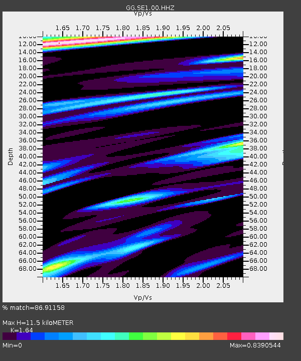
| Estimated Moho Depth: |
11.5 km |
| Estimated Crust Vp/Vs: |
1.64 |
| Assumed Crust Vp: |
6.424 km/s |
| Estimated Crust Vs: |
3.917 km/s |
| Estimated Crust Poisson's Ratio: |
0.20 |
|
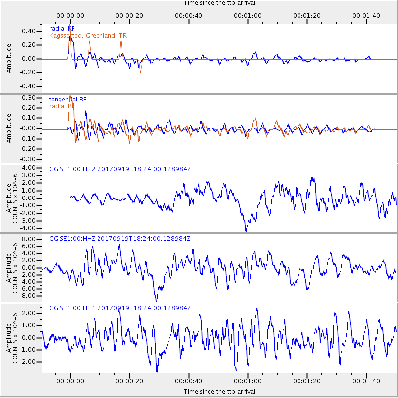
| Radial Match: |
86.91158 % |
| Radial Bump: |
400 |
| Transverse Match: |
64.41944 % |
| Transverse Bump: |
400 |
| SOD ConfigId: |
2973751 |
| Insert Time: |
2018-10-08 23:00:59.979 +0000 |
| GWidth: |
2.5 |
| Max Bumps: |
400 |
| Tol: |
0.001 |
|
Signal To Noise
| Channel | StoN | STA | LTA |
| GG:SE1:00:HHZ:20170919T18:24:00.128984Z | 5.4093785 | 2.7418166E-6 | 5.068635E-7 |
| GG:SE1:00:HH1:20170919T18:24:00.128984Z | 1.2624078 | 6.549437E-7 | 5.1880517E-7 |
| GG:SE1:00:HH2:20170919T18:24:00.128984Z | 3.2887006 | 1.1824983E-6 | 3.5956398E-7 |
| Arrivals |
| Ps | 1.2 SECOND |
| PpPs | 4.5 SECOND |
| PsPs/PpSs | 5.7 SECOND |


