You are here: Home > Network List > CB - China National Seismic Network Stations List
> Station GOM Geermu,Qinghai Province > Earthquake Result Viewer
GOM Geermu,Qinghai Province - Earthquake Result Viewer
| Earthquake location: |
Off East Coast Of Honshu, Japan |
| Earthquake latitude/longitude: |
38.0/144.7 |
| Earthquake time(UTC): |
2017/09/20 (263) 16:37:16 GMT |
| Earthquake Depth: |
10 km |
| Earthquake Magnitude: |
6.1 Mww |
| Earthquake Catalog/Contributor: |
NEIC PDE/us |
|
| Network: |
CB China National Seismic Network |
| Station: |
GOM Geermu,Qinghai Province |
| Lat/Lon: |
36.20 N/94.81 E |
| Elevation: |
3121 m |
|
| Distance: |
39.4 deg |
| Az: |
283.202 deg |
| Baz: |
72.011 deg |
| Ray Param: |
0.07499081 |
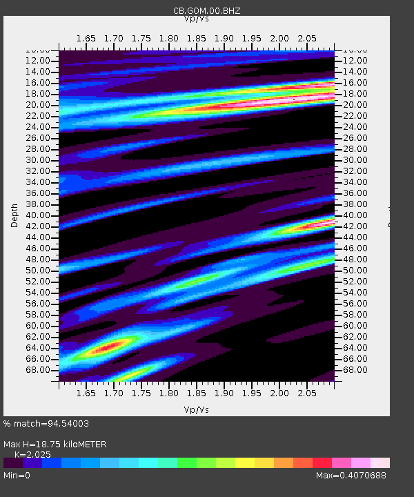
| Estimated Moho Depth: |
18.75 km |
| Estimated Crust Vp/Vs: |
2.03 |
| Assumed Crust Vp: |
6.385 km/s |
| Estimated Crust Vs: |
3.153 km/s |
| Estimated Crust Poisson's Ratio: |
0.34 |
|
| Radial Match: |
94.54003 % |
| Radial Bump: |
184 |
| Transverse Match: |
77.40599 % |
| Transverse Bump: |
400 |
| SOD ConfigId: |
2973751 |
| Insert Time: |
2018-10-08 23:09:12.430 +0000 |
| GWidth: |
2.5 |
| Max Bumps: |
400 |
| Tol: |
0.001 |
|

Signal To Noise
| Channel | StoN | STA | LTA |
| CB:GOM:00:BHZ:20170920T16:44:15.339985Z | 1.8515334 | 3.828401E-6 | 2.067692E-6 |
| CB:GOM:00:BHN:20170920T16:44:15.339985Z | 1.0361614 | 1.8857096E-6 | 1.8198995E-6 |
| CB:GOM:00:BHE:20170920T16:44:15.339985Z | 1.7793523 | 1.4198348E-6 | 7.9795035E-7 |
| Arrivals |
| Ps | 3.2 SECOND |
| PpPs | 8.4 SECOND |
| PsPs/PpSs | 12 SECOND |


