You are here: Home > Network List > TA - USArray Transportable Network (new EarthScope stations) Stations List
> Station BRSD Miller, SD, USA > Earthquake Result Viewer
BRSD Miller, SD, USA - Earthquake Result Viewer
| Earthquake location: |
East Central Pacific Ocean |
| Earthquake latitude/longitude: |
8.3/-110.4 |
| Earthquake time(UTC): |
2010/01/21 (021) 08:03:22 GMT |
| Earthquake Depth: |
10 km |
| Earthquake Magnitude: |
5.8 MB, 5.3 MS, 5.6 MW, 5.6 MW |
| Earthquake Catalog/Contributor: |
WHDF/NEIC |
|
| Network: |
TA USArray Transportable Network (new EarthScope stations) |
| Station: |
BRSD Miller, SD, USA |
| Lat/Lon: |
44.44 N/98.96 W |
| Elevation: |
519 m |
|
| Distance: |
37.4 deg |
| Az: |
13.49 deg |
| Baz: |
198.804 deg |
| Ray Param: |
0.07616655 |
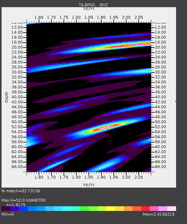
| Estimated Moho Depth: |
52.0 km |
| Estimated Crust Vp/Vs: |
1.92 |
| Assumed Crust Vp: |
6.53 km/s |
| Estimated Crust Vs: |
3.406 km/s |
| Estimated Crust Poisson's Ratio: |
0.31 |
|
| Radial Match: |
82.73156 % |
| Radial Bump: |
400 |
| Transverse Match: |
62.191788 % |
| Transverse Bump: |
400 |
| SOD ConfigId: |
296938 |
| Insert Time: |
2010-04-06 22:40:04.000 +0000 |
| GWidth: |
2.5 |
| Max Bumps: |
400 |
| Tol: |
0.001 |
|
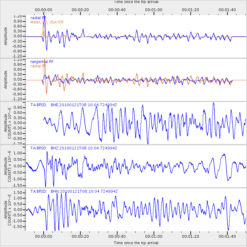
Signal To Noise
| Channel | StoN | STA | LTA |
| TA:BRSD: :BHZ:20100121T08:10:04.724994Z | 2.1840577 | 6.182106E-7 | 2.8305598E-7 |
| TA:BRSD: :BHN:20100121T08:10:04.724994Z | 3.116539 | 7.4066696E-7 | 2.3765689E-7 |
| TA:BRSD: :BHE:20100121T08:10:04.724994Z | 1.6708931 | 6.489866E-7 | 3.88407E-7 |
| Arrivals |
| Ps | 7.8 SECOND |
| PpPs | 22 SECOND |
| PsPs/PpSs | 29 SECOND |


