You are here: Home > Network List > TA - USArray Transportable Network (new EarthScope stations) Stations List
> Station BGNE Belgrade, NE, USA > Earthquake Result Viewer
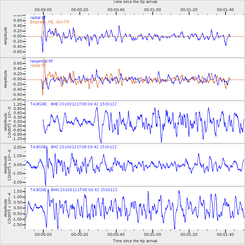
BGNE Belgrade, NE, USA - Earthquake Result Viewer
*The percent match for this event was below the threshold and hence no stack was calculated.
| Earthquake location: |
East Central Pacific Ocean |
| Earthquake latitude/longitude: |
8.3/-110.4 |
| Earthquake time(UTC): |
2010/01/21 (021) 08:03:22 GMT |
| Earthquake Depth: |
10 km |
| Earthquake Magnitude: |
5.8 MB, 5.3 MS, 5.6 MW, 5.6 MW |
| Earthquake Catalog/Contributor: |
WHDF/NEIC |
|
| Network: |
TA USArray Transportable Network (new EarthScope stations) |
| Station: |
BGNE Belgrade, NE, USA |
| Lat/Lon: |
41.41 N/98.15 W |
| Elevation: |
573 m |
|
| Distance: |
34.7 deg |
| Az: |
16.211 deg |
| Baz: |
201.552 deg |
| Ray Param: |
$rayparam |
*The percent match for this event was below the threshold and hence was not used in the summary stack. |
|
| Radial Match: |
61.006706 % |
| Radial Bump: |
400 |
| Transverse Match: |
54.568375 % |
| Transverse Bump: |
400 |
| SOD ConfigId: |
296938 |
| Insert Time: |
2010-04-06 22:40:47.584 +0000 |
| GWidth: |
2.5 |
| Max Bumps: |
400 |
| Tol: |
0.001 |
|
Signal To Noise
| Channel | StoN | STA | LTA |
| TA:BGNE: :BHZ:20100121T08:09:42.150012Z | 3.2492352 | 8.9379193E-7 | 2.7507764E-7 |
| TA:BGNE: :BHN:20100121T08:09:42.150012Z | 2.07517 | 8.499158E-7 | 4.0956442E-7 |
| TA:BGNE: :BHE:20100121T08:09:42.150012Z | 2.653243 | 7.953432E-7 | 2.9976266E-7 |
| Arrivals |
| Ps | |
| PpPs | |
| PsPs/PpSs | |


