You are here: Home > Network List > TA - USArray Transportable Network (new EarthScope stations) Stations List
> Station F24A Ekalaka, MT, USA > Earthquake Result Viewer
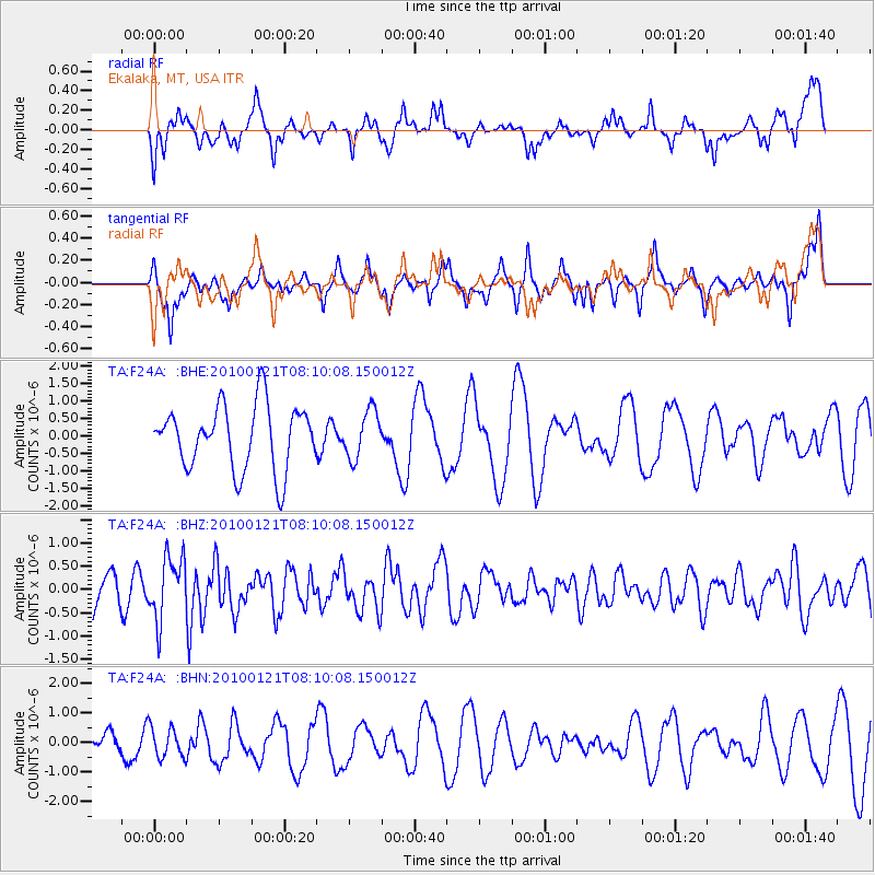
F24A Ekalaka, MT, USA - Earthquake Result Viewer
*The percent match for this event was below the threshold and hence no stack was calculated.
| Earthquake location: |
East Central Pacific Ocean |
| Earthquake latitude/longitude: |
8.3/-110.4 |
| Earthquake time(UTC): |
2010/01/21 (021) 08:03:22 GMT |
| Earthquake Depth: |
10 km |
| Earthquake Magnitude: |
5.8 MB, 5.3 MS, 5.6 MW, 5.6 MW |
| Earthquake Catalog/Contributor: |
WHDF/NEIC |
|
| Network: |
TA USArray Transportable Network (new EarthScope stations) |
| Station: |
F24A Ekalaka, MT, USA |
| Lat/Lon: |
45.85 N/104.44 W |
| Elevation: |
1105 m |
|
| Distance: |
37.8 deg |
| Az: |
6.752 deg |
| Baz: |
189.582 deg |
| Ray Param: |
$rayparam |
*The percent match for this event was below the threshold and hence was not used in the summary stack. |
|
| Radial Match: |
50.89373 % |
| Radial Bump: |
388 |
| Transverse Match: |
44.17367 % |
| Transverse Bump: |
341 |
| SOD ConfigId: |
296938 |
| Insert Time: |
2010-04-06 22:41:04.060 +0000 |
| GWidth: |
2.5 |
| Max Bumps: |
400 |
| Tol: |
0.001 |
|
Signal To Noise
| Channel | StoN | STA | LTA |
| TA:F24A: :BHZ:20100121T08:10:08.150012Z | 2.039986 | 6.7253995E-7 | 3.2967873E-7 |
| TA:F24A: :BHN:20100121T08:10:08.150012Z | 1.0569636 | 5.0642547E-7 | 4.791324E-7 |
| TA:F24A: :BHE:20100121T08:10:08.150012Z | 0.7374226 | 6.828558E-7 | 9.2600334E-7 |
| Arrivals |
| Ps | |
| PpPs | |
| PsPs/PpSs | |


