You are here: Home > Network List > TA - USArray Transportable Network (new EarthScope stations) Stations List
> Station J28A Allard Ranch, Norris, SD, USA > Earthquake Result Viewer
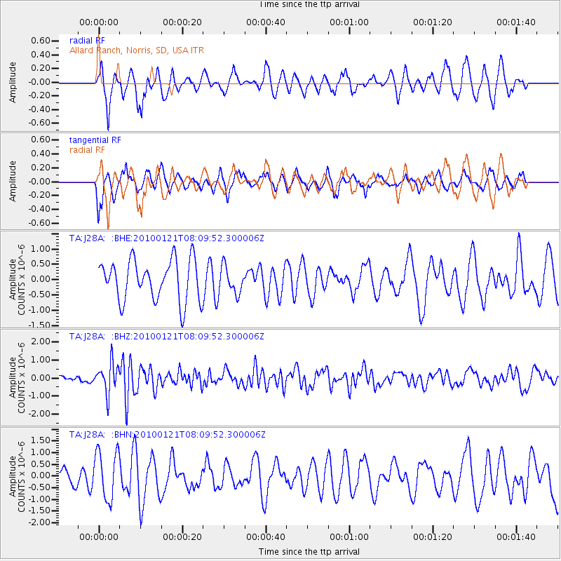
J28A Allard Ranch, Norris, SD, USA - Earthquake Result Viewer
*The percent match for this event was below the threshold and hence no stack was calculated.
| Earthquake location: |
East Central Pacific Ocean |
| Earthquake latitude/longitude: |
8.3/-110.4 |
| Earthquake time(UTC): |
2010/01/21 (021) 08:03:22 GMT |
| Earthquake Depth: |
10 km |
| Earthquake Magnitude: |
5.8 MB, 5.3 MS, 5.6 MW, 5.6 MW |
| Earthquake Catalog/Contributor: |
WHDF/NEIC |
|
| Network: |
TA USArray Transportable Network (new EarthScope stations) |
| Station: |
J28A Allard Ranch, Norris, SD, USA |
| Lat/Lon: |
43.42 N/101.24 W |
| Elevation: |
835 m |
|
| Distance: |
35.9 deg |
| Az: |
11.357 deg |
| Baz: |
195.516 deg |
| Ray Param: |
$rayparam |
*The percent match for this event was below the threshold and hence was not used in the summary stack. |
|
| Radial Match: |
58.28457 % |
| Radial Bump: |
339 |
| Transverse Match: |
52.538773 % |
| Transverse Bump: |
397 |
| SOD ConfigId: |
296938 |
| Insert Time: |
2010-04-06 22:44:42.488 +0000 |
| GWidth: |
2.5 |
| Max Bumps: |
400 |
| Tol: |
0.001 |
|
Signal To Noise
| Channel | StoN | STA | LTA |
| TA:J28A: :BHZ:20100121T08:09:52.300006Z | 4.0068007 | 8.480338E-7 | 2.116486E-7 |
| TA:J28A: :BHN:20100121T08:09:52.300006Z | 2.2595005 | 1.0655904E-6 | 4.716044E-7 |
| TA:J28A: :BHE:20100121T08:09:52.300006Z | 0.65207535 | 4.3280406E-7 | 6.637332E-7 |
| Arrivals |
| Ps | |
| PpPs | |
| PsPs/PpSs | |


