You are here: Home > Network List > TA - USArray Transportable Network (new EarthScope stations) Stations List
> Station L28A Connealy Angus Ranch, Whitman, NE, USA > Earthquake Result Viewer
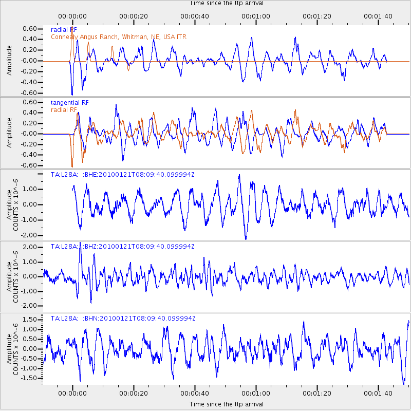
L28A Connealy Angus Ranch, Whitman, NE, USA - Earthquake Result Viewer
*The percent match for this event was below the threshold and hence no stack was calculated.
| Earthquake location: |
East Central Pacific Ocean |
| Earthquake latitude/longitude: |
8.3/-110.4 |
| Earthquake time(UTC): |
2010/01/21 (021) 08:03:22 GMT |
| Earthquake Depth: |
10 km |
| Earthquake Magnitude: |
5.8 MB, 5.3 MS, 5.6 MW, 5.6 MW |
| Earthquake Catalog/Contributor: |
WHDF/NEIC |
|
| Network: |
TA USArray Transportable Network (new EarthScope stations) |
| Station: |
L28A Connealy Angus Ranch, Whitman, NE, USA |
| Lat/Lon: |
42.01 N/101.52 W |
| Elevation: |
1155 m |
|
| Distance: |
34.5 deg |
| Az: |
11.666 deg |
| Baz: |
195.577 deg |
| Ray Param: |
$rayparam |
*The percent match for this event was below the threshold and hence was not used in the summary stack. |
|
| Radial Match: |
57.694115 % |
| Radial Bump: |
340 |
| Transverse Match: |
52.953148 % |
| Transverse Bump: |
323 |
| SOD ConfigId: |
296938 |
| Insert Time: |
2010-04-06 22:44:55.860 +0000 |
| GWidth: |
2.5 |
| Max Bumps: |
400 |
| Tol: |
0.001 |
|
Signal To Noise
| Channel | StoN | STA | LTA |
| TA:L28A: :BHZ:20100121T08:09:40.099994Z | 4.4043465 | 8.6235934E-7 | 1.9579736E-7 |
| TA:L28A: :BHN:20100121T08:09:40.099994Z | 0.9111086 | 6.2953546E-7 | 6.909554E-7 |
| TA:L28A: :BHE:20100121T08:09:40.099994Z | 0.883605 | 5.709737E-7 | 6.4618666E-7 |
| Arrivals |
| Ps | |
| PpPs | |
| PsPs/PpSs | |


