You are here: Home > Network List > US - United States National Seismic Network Stations List
> Station CBKS Cedar Bluff, Kansas, USA > Earthquake Result Viewer
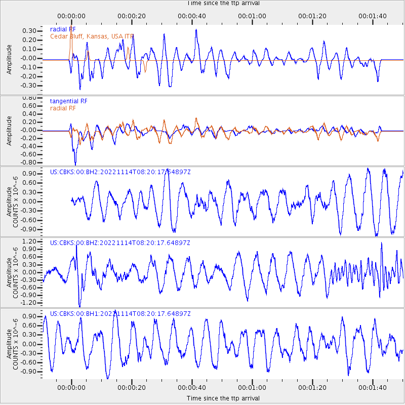
CBKS Cedar Bluff, Kansas, USA - Earthquake Result Viewer
*The percent match for this event was below the threshold and hence no stack was calculated.
| Earthquake location: |
Near S. Coast Of Honshu, Japan |
| Earthquake latitude/longitude: |
33.8/137.3 |
| Earthquake time(UTC): |
2022/11/14 (318) 08:08:26 GMT |
| Earthquake Depth: |
357 km |
| Earthquake Magnitude: |
6.1 mww |
| Earthquake Catalog/Contributor: |
NEIC PDE/us |
|
| Network: |
US United States National Seismic Network |
| Station: |
CBKS Cedar Bluff, Kansas, USA |
| Lat/Lon: |
38.81 N/99.74 W |
| Elevation: |
677 m |
|
| Distance: |
90.5 deg |
| Az: |
40.932 deg |
| Baz: |
315.708 deg |
| Ray Param: |
$rayparam |
*The percent match for this event was below the threshold and hence was not used in the summary stack. |
|
| Radial Match: |
59.564278 % |
| Radial Bump: |
400 |
| Transverse Match: |
77.674576 % |
| Transverse Bump: |
400 |
| SOD ConfigId: |
29823551 |
| Insert Time: |
2022-11-28 08:43:13.507 +0000 |
| GWidth: |
2.5 |
| Max Bumps: |
400 |
| Tol: |
0.001 |
|
Signal To Noise
| Channel | StoN | STA | LTA |
| US:CBKS:00:BHZ:20221114T08:20:17.64897Z | 3.048129 | 6.293453E-7 | 2.0646938E-7 |
| US:CBKS:00:BH1:20221114T08:20:17.64897Z | 1.1355083 | 4.1394202E-7 | 3.6454338E-7 |
| US:CBKS:00:BH2:20221114T08:20:17.64897Z | 2.500717 | 7.56931E-7 | 3.026856E-7 |
| Arrivals |
| Ps | |
| PpPs | |
| PsPs/PpSs | |


