You are here: Home > Network List > US - United States National Seismic Network Stations List
> Station DGMT Dagmar, Montana, USA > Earthquake Result Viewer
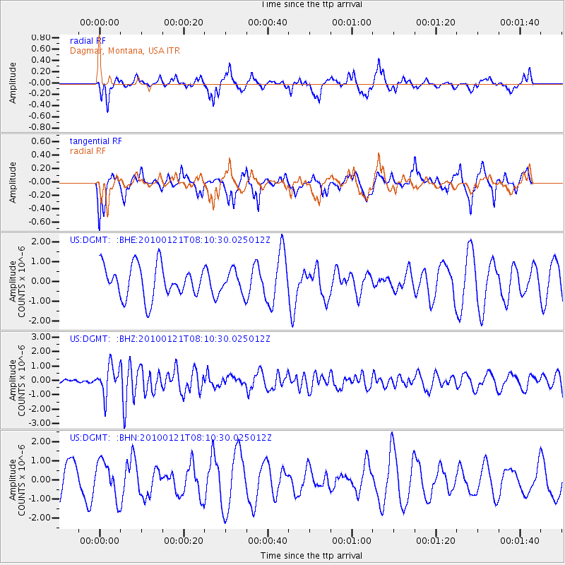
DGMT Dagmar, Montana, USA - Earthquake Result Viewer
*The percent match for this event was below the threshold and hence no stack was calculated.
| Earthquake location: |
East Central Pacific Ocean |
| Earthquake latitude/longitude: |
8.3/-110.4 |
| Earthquake time(UTC): |
2010/01/21 (021) 08:03:22 GMT |
| Earthquake Depth: |
10 km |
| Earthquake Magnitude: |
5.8 MB, 5.3 MS, 5.6 MW, 5.6 MW |
| Earthquake Catalog/Contributor: |
WHDF/NEIC |
|
| Network: |
US United States National Seismic Network |
| Station: |
DGMT Dagmar, Montana, USA |
| Lat/Lon: |
48.47 N/104.20 W |
| Elevation: |
0.0 m |
|
| Distance: |
40.4 deg |
| Az: |
6.33 deg |
| Baz: |
189.438 deg |
| Ray Param: |
$rayparam |
*The percent match for this event was below the threshold and hence was not used in the summary stack. |
|
| Radial Match: |
35.93975 % |
| Radial Bump: |
315 |
| Transverse Match: |
54.24874 % |
| Transverse Bump: |
400 |
| SOD ConfigId: |
296938 |
| Insert Time: |
2010-04-06 22:52:11.523 +0000 |
| GWidth: |
2.5 |
| Max Bumps: |
400 |
| Tol: |
0.001 |
|
Signal To Noise
| Channel | StoN | STA | LTA |
| US:DGMT: :BHZ:20100121T08:10:30.025012Z | 3.611713 | 1.0102268E-6 | 2.797085E-7 |
| US:DGMT: :BHN:20100121T08:10:30.025012Z | 1.2997726 | 9.577834E-7 | 7.3688534E-7 |
| US:DGMT: :BHE:20100121T08:10:30.025012Z | 0.6969637 | 5.653946E-7 | 8.1122533E-7 |
| Arrivals |
| Ps | |
| PpPs | |
| PsPs/PpSs | |


