You are here: Home > Network List > UW - Pacific Northwest Regional Seismic Network Stations List
> Station IRON Crane, OR, USA > Earthquake Result Viewer
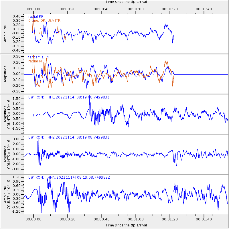
IRON Crane, OR, USA - Earthquake Result Viewer
*The percent match for this event was below the threshold and hence no stack was calculated.
| Earthquake location: |
Near S. Coast Of Honshu, Japan |
| Earthquake latitude/longitude: |
33.8/137.3 |
| Earthquake time(UTC): |
2022/11/14 (318) 08:08:26 GMT |
| Earthquake Depth: |
357 km |
| Earthquake Magnitude: |
6.1 mww |
| Earthquake Catalog/Contributor: |
NEIC PDE/us |
|
| Network: |
UW Pacific Northwest Regional Seismic Network |
| Station: |
IRON Crane, OR, USA |
| Lat/Lon: |
43.36 N/118.47 W |
| Elevation: |
1226 m |
|
| Distance: |
76.8 deg |
| Az: |
46.567 deg |
| Baz: |
303.999 deg |
| Ray Param: |
$rayparam |
*The percent match for this event was below the threshold and hence was not used in the summary stack. |
|
| Radial Match: |
67.89205 % |
| Radial Bump: |
400 |
| Transverse Match: |
68.72901 % |
| Transverse Bump: |
400 |
| SOD ConfigId: |
29823551 |
| Insert Time: |
2022-11-28 08:46:00.460 +0000 |
| GWidth: |
2.5 |
| Max Bumps: |
400 |
| Tol: |
0.001 |
|
Signal To Noise
| Channel | StoN | STA | LTA |
| UW:IRON: :HHZ:20221114T08:19:08.749983Z | 5.4778695 | 1.0286439E-6 | 1.8778174E-7 |
| UW:IRON: :HHN:20221114T08:19:08.749983Z | 1.7824132 | 3.3566818E-7 | 1.883223E-7 |
| UW:IRON: :HHE:20221114T08:19:08.749983Z | 3.6581438 | 5.895834E-7 | 1.611701E-7 |
| Arrivals |
| Ps | |
| PpPs | |
| PsPs/PpSs | |


