You are here: Home > Network List > IU - Global Seismograph Network (GSN - IRIS/USGS) Stations List
> Station SLBS Sierra la Laguna Baja California Sur, Mexico > Earthquake Result Viewer
SLBS Sierra la Laguna Baja California Sur, Mexico - Earthquake Result Viewer
| Earthquake location: |
Pacific-Antarctic Ridge |
| Earthquake latitude/longitude: |
-64.0/-167.8 |
| Earthquake time(UTC): |
2022/11/14 (318) 15:01:52 GMT |
| Earthquake Depth: |
10 km |
| Earthquake Magnitude: |
5.6 Mwb |
| Earthquake Catalog/Contributor: |
NEIC PDE/us |
|
| Network: |
IU Global Seismograph Network (GSN - IRIS/USGS) |
| Station: |
SLBS Sierra la Laguna Baja California Sur, Mexico |
| Lat/Lon: |
23.69 N/109.94 W |
| Elevation: |
825 m |
|
| Distance: |
98.3 deg |
| Az: |
51.673 deg |
| Baz: |
202.154 deg |
| Ray Param: |
0.039957598 |
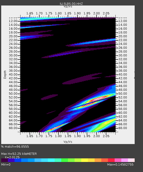
| Estimated Moho Depth: |
52.25 km |
| Estimated Crust Vp/Vs: |
2.01 |
| Assumed Crust Vp: |
6.183 km/s |
| Estimated Crust Vs: |
3.072 km/s |
| Estimated Crust Poisson's Ratio: |
0.34 |
|
| Radial Match: |
96.8555 % |
| Radial Bump: |
103 |
| Transverse Match: |
96.88678 % |
| Transverse Bump: |
94 |
| SOD ConfigId: |
29823551 |
| Insert Time: |
2022-11-28 15:05:08.654 +0000 |
| GWidth: |
2.5 |
| Max Bumps: |
400 |
| Tol: |
0.001 |
|

Signal To Noise
| Channel | StoN | STA | LTA |
| IU:SLBS:00:HHZ:20221114T15:14:58.41801Z | 56.25624 | 3.7079403E-6 | 6.591163E-8 |
| IU:SLBS:00:HH1:20221114T15:14:58.41801Z | 58.21872 | 3.3549136E-6 | 5.762603E-8 |
| IU:SLBS:00:HH2:20221114T15:14:58.41801Z | 58.358692 | 3.3471683E-6 | 5.7355095E-8 |
| Arrivals |
| Ps | 8.7 SECOND |
| PpPs | 25 SECOND |
| PsPs/PpSs | 34 SECOND |


