You are here: Home > Network List > AK - Alaska Regional Network Stations List
> Station PS08 TAPS Pump Station 8, AK, USA > Earthquake Result Viewer
PS08 TAPS Pump Station 8, AK, USA - Earthquake Result Viewer
| Earthquake location: |
Santa Cruz Islands |
| Earthquake latitude/longitude: |
-11.7/166.6 |
| Earthquake time(UTC): |
2022/11/16 (320) 22:26:52 GMT |
| Earthquake Depth: |
138 km |
| Earthquake Magnitude: |
5.8 mww |
| Earthquake Catalog/Contributor: |
NEIC PDE/us |
|
| Network: |
AK Alaska Regional Network |
| Station: |
PS08 TAPS Pump Station 8, AK, USA |
| Lat/Lon: |
64.54 N/146.82 W |
| Elevation: |
320 m |
|
| Distance: |
83.7 deg |
| Az: |
18.404 deg |
| Baz: |
225.677 deg |
| Ray Param: |
0.04565725 |
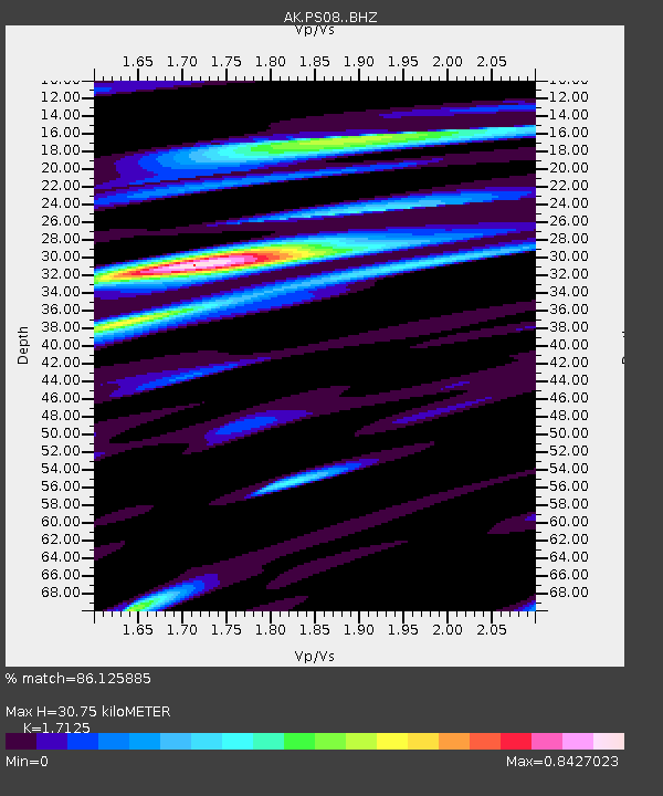
| Estimated Moho Depth: |
30.75 km |
| Estimated Crust Vp/Vs: |
1.71 |
| Assumed Crust Vp: |
6.566 km/s |
| Estimated Crust Vs: |
3.834 km/s |
| Estimated Crust Poisson's Ratio: |
0.24 |
|
| Radial Match: |
86.125885 % |
| Radial Bump: |
400 |
| Transverse Match: |
72.37789 % |
| Transverse Bump: |
400 |
| SOD ConfigId: |
29823551 |
| Insert Time: |
2022-11-30 22:31:19.088 +0000 |
| GWidth: |
2.5 |
| Max Bumps: |
400 |
| Tol: |
0.001 |
|

Signal To Noise
| Channel | StoN | STA | LTA |
| AK:PS08: :BHZ:20221116T22:38:35.187985Z | 7.38421 | 1.9502747E-6 | 2.641142E-7 |
| AK:PS08: :BHN:20221116T22:38:35.187985Z | 2.795646 | 4.9846363E-7 | 1.7829997E-7 |
| AK:PS08: :BHE:20221116T22:38:35.187985Z | 2.9230528 | 5.238172E-7 | 1.792021E-7 |
| Arrivals |
| Ps | 3.4 SECOND |
| PpPs | 12 SECOND |
| PsPs/PpSs | 16 SECOND |


