You are here: Home > Network List > TA - USArray Transportable Network (new EarthScope stations) Stations List
> Station T23A Casias Ranch, Antonito, CO, USA > Earthquake Result Viewer
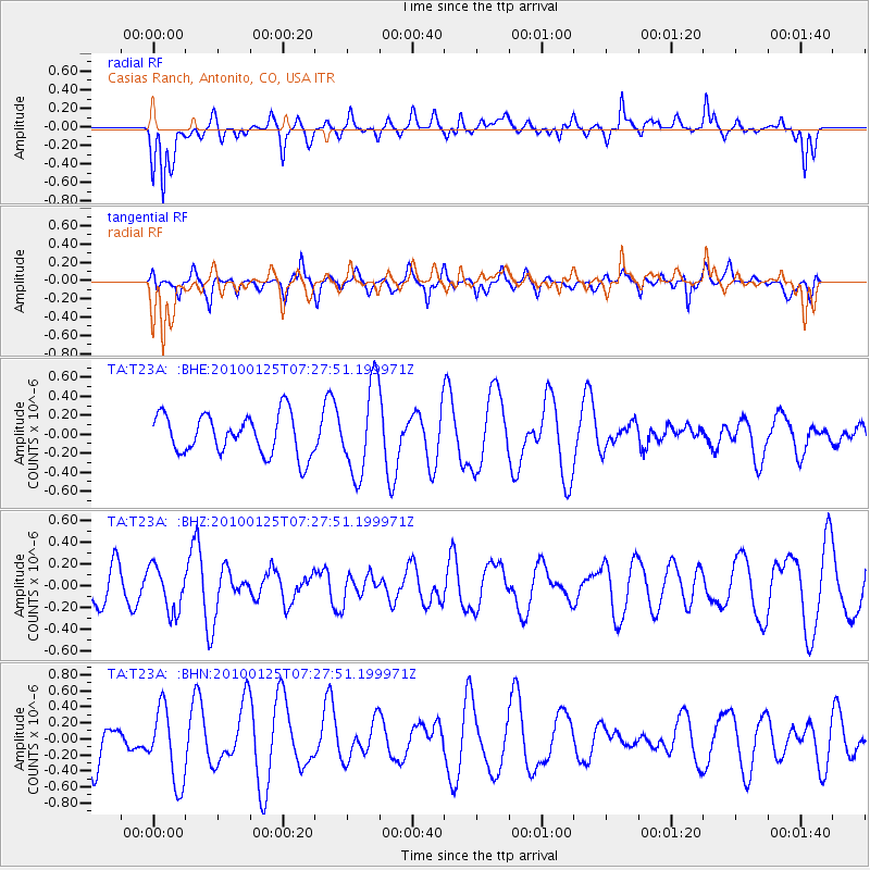
T23A Casias Ranch, Antonito, CO, USA - Earthquake Result Viewer
*The percent match for this event was below the threshold and hence no stack was calculated.
| Earthquake location: |
Kyushu, Japan |
| Earthquake latitude/longitude: |
31.0/130.9 |
| Earthquake time(UTC): |
2010/01/25 (025) 07:15:08 GMT |
| Earthquake Depth: |
38 km |
| Earthquake Magnitude: |
5.5 MB, 4.9 MS, 5.5 MW, 5.5 MW |
| Earthquake Catalog/Contributor: |
WHDF/NEIC |
|
| Network: |
TA USArray Transportable Network (new EarthScope stations) |
| Station: |
T23A Casias Ranch, Antonito, CO, USA |
| Lat/Lon: |
37.04 N/106.04 W |
| Elevation: |
2429 m |
|
| Distance: |
93.9 deg |
| Az: |
42.229 deg |
| Baz: |
313.823 deg |
| Ray Param: |
$rayparam |
*The percent match for this event was below the threshold and hence was not used in the summary stack. |
|
| Radial Match: |
44.180576 % |
| Radial Bump: |
357 |
| Transverse Match: |
59.156384 % |
| Transverse Bump: |
400 |
| SOD ConfigId: |
296938 |
| Insert Time: |
2010-04-06 23:06:58.474 +0000 |
| GWidth: |
2.5 |
| Max Bumps: |
400 |
| Tol: |
0.001 |
|
Signal To Noise
| Channel | StoN | STA | LTA |
| TA:T23A: :BHZ:20100125T07:27:51.199971Z | 1.3452731 | 2.0964106E-7 | 1.5583531E-7 |
| TA:T23A: :BHN:20100125T07:27:51.199971Z | 1.7644461 | 4.610789E-7 | 2.613165E-7 |
| TA:T23A: :BHE:20100125T07:27:51.199971Z | 2.211307 | 4.6802813E-7 | 2.1165226E-7 |
| Arrivals |
| Ps | |
| PpPs | |
| PsPs/PpSs | |


