You are here: Home > Network List > TA - USArray Transportable Network (new EarthScope stations) Stations List
> Station J26A Sides Ranch, Smithwick, SD, USA > Earthquake Result Viewer
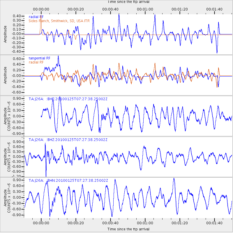
J26A Sides Ranch, Smithwick, SD, USA - Earthquake Result Viewer
*The percent match for this event was below the threshold and hence no stack was calculated.
| Earthquake location: |
Kyushu, Japan |
| Earthquake latitude/longitude: |
31.0/130.9 |
| Earthquake time(UTC): |
2010/01/25 (025) 07:15:08 GMT |
| Earthquake Depth: |
38 km |
| Earthquake Magnitude: |
5.5 MB, 4.9 MS, 5.5 MW, 5.5 MW |
| Earthquake Catalog/Contributor: |
WHDF/NEIC |
|
| Network: |
TA USArray Transportable Network (new EarthScope stations) |
| Station: |
J26A Sides Ranch, Smithwick, SD, USA |
| Lat/Lon: |
43.31 N/103.08 W |
| Elevation: |
993 m |
|
| Distance: |
91.1 deg |
| Az: |
36.182 deg |
| Baz: |
315.992 deg |
| Ray Param: |
$rayparam |
*The percent match for this event was below the threshold and hence was not used in the summary stack. |
|
| Radial Match: |
40.48699 % |
| Radial Bump: |
400 |
| Transverse Match: |
54.651386 % |
| Transverse Bump: |
400 |
| SOD ConfigId: |
296938 |
| Insert Time: |
2010-04-06 23:08:16.011 +0000 |
| GWidth: |
2.5 |
| Max Bumps: |
400 |
| Tol: |
0.001 |
|
Signal To Noise
| Channel | StoN | STA | LTA |
| TA:J26A: :BHZ:20100125T07:27:38.25002Z | 1.1163274 | 3.4509708E-7 | 3.091361E-7 |
| TA:J26A: :BHN:20100125T07:27:38.25002Z | 1.3704897 | 5.5865377E-7 | 4.0763075E-7 |
| TA:J26A: :BHE:20100125T07:27:38.25002Z | 1.507873 | 5.7968157E-7 | 3.8443656E-7 |
| Arrivals |
| Ps | |
| PpPs | |
| PsPs/PpSs | |


