You are here: Home > Network List > CI - Caltech Regional Seismic Network Stations List
> Station GLA Glamis, Glamis, CA, USA > Earthquake Result Viewer
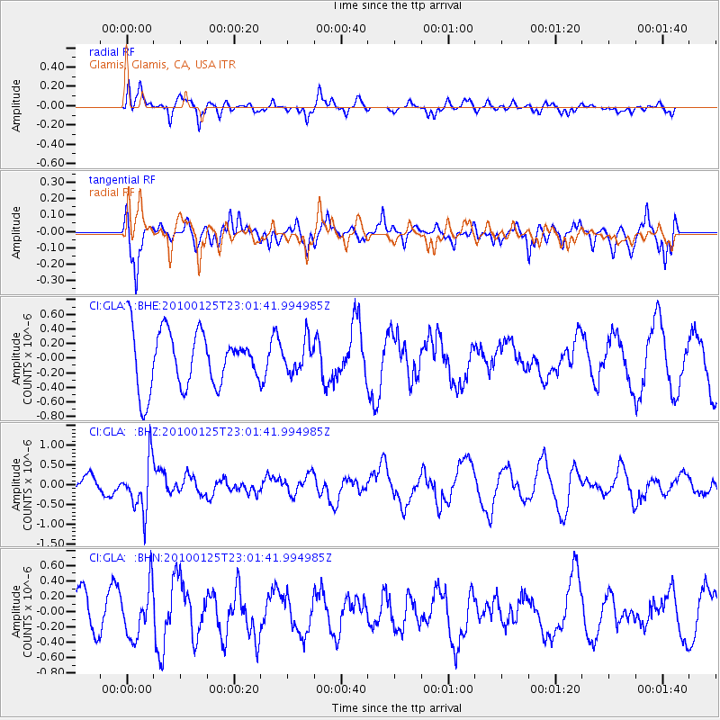
GLA Glamis, Glamis, CA, USA - Earthquake Result Viewer
*The percent match for this event was below the threshold and hence no stack was calculated.
| Earthquake location: |
Peru-Brazil Border Region |
| Earthquake latitude/longitude: |
-8.5/-74.5 |
| Earthquake time(UTC): |
2010/01/25 (025) 22:52:46 GMT |
| Earthquake Depth: |
147 km |
| Earthquake Magnitude: |
5.7 MB, 5.9 MW, 5.9 MW |
| Earthquake Catalog/Contributor: |
WHDF/NEIC |
|
| Network: |
CI Caltech Regional Seismic Network |
| Station: |
GLA Glamis, Glamis, CA, USA |
| Lat/Lon: |
33.05 N/114.83 W |
| Elevation: |
610 m |
|
| Distance: |
56.4 deg |
| Az: |
319.235 deg |
| Baz: |
129.732 deg |
| Ray Param: |
$rayparam |
*The percent match for this event was below the threshold and hence was not used in the summary stack. |
|
| Radial Match: |
65.841095 % |
| Radial Bump: |
400 |
| Transverse Match: |
57.386063 % |
| Transverse Bump: |
344 |
| SOD ConfigId: |
296938 |
| Insert Time: |
2010-04-06 23:13:18.427 +0000 |
| GWidth: |
2.5 |
| Max Bumps: |
400 |
| Tol: |
0.001 |
|
Signal To Noise
| Channel | StoN | STA | LTA |
| CI:GLA: :BHZ:20100125T23:01:41.994985Z | 2.4981418 | 6.4803123E-7 | 2.594053E-7 |
| CI:GLA: :BHN:20100125T23:01:41.994985Z | 0.73751277 | 3.2722502E-7 | 4.4368727E-7 |
| CI:GLA: :BHE:20100125T23:01:41.994985Z | 0.54791147 | 2.1041032E-7 | 3.8402246E-7 |
| Arrivals |
| Ps | |
| PpPs | |
| PsPs/PpSs | |


