You are here: Home > Network List > IW - Intermountain West Stations List
> Station MOOW Moose Ponds, Wyoming, USA > Earthquake Result Viewer
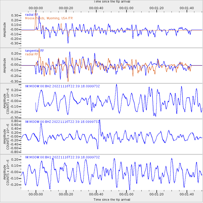
MOOW Moose Ponds, Wyoming, USA - Earthquake Result Viewer
*The percent match for this event was below the threshold and hence no stack was calculated.
| Earthquake location: |
Santa Cruz Islands |
| Earthquake latitude/longitude: |
-11.7/166.6 |
| Earthquake time(UTC): |
2022/11/16 (320) 22:26:52 GMT |
| Earthquake Depth: |
138 km |
| Earthquake Magnitude: |
5.8 mww |
| Earthquake Catalog/Contributor: |
NEIC PDE/us |
|
| Network: |
IW Intermountain West |
| Station: |
MOOW Moose Ponds, Wyoming, USA |
| Lat/Lon: |
43.75 N/110.74 W |
| Elevation: |
2128 m |
|
| Distance: |
92.8 deg |
| Az: |
46.018 deg |
| Baz: |
256.52 deg |
| Ray Param: |
$rayparam |
*The percent match for this event was below the threshold and hence was not used in the summary stack. |
|
| Radial Match: |
62.95876 % |
| Radial Bump: |
400 |
| Transverse Match: |
64.99149 % |
| Transverse Bump: |
400 |
| SOD ConfigId: |
29823551 |
| Insert Time: |
2022-11-30 22:46:30.162 +0000 |
| GWidth: |
2.5 |
| Max Bumps: |
400 |
| Tol: |
0.001 |
|
Signal To Noise
| Channel | StoN | STA | LTA |
| IW:MOOW:00:BHZ:20221116T22:39:18.099973Z | 3.9041855 | 2.9649058E-7 | 7.594172E-8 |
| IW:MOOW:00:BH1:20221116T22:39:18.099973Z | 1.9068512 | 1.301402E-7 | 6.8248745E-8 |
| IW:MOOW:00:BH2:20221116T22:39:18.099973Z | 0.34337392 | 3.9135017E-8 | 1.13972014E-7 |
| Arrivals |
| Ps | |
| PpPs | |
| PsPs/PpSs | |


