You are here: Home > Network List > TM - Thai Seismic Monitoring Network Stations List
> Station SURA Don Sak, Surat Thani > Earthquake Result Viewer
SURA Don Sak, Surat Thani - Earthquake Result Viewer
| Earthquake location: |
Santa Cruz Islands |
| Earthquake latitude/longitude: |
-11.7/166.6 |
| Earthquake time(UTC): |
2022/11/16 (320) 22:26:52 GMT |
| Earthquake Depth: |
138 km |
| Earthquake Magnitude: |
5.8 mww |
| Earthquake Catalog/Contributor: |
NEIC PDE/us |
|
| Network: |
TM Thai Seismic Monitoring Network |
| Station: |
SURA Don Sak, Surat Thani |
| Lat/Lon: |
9.17 N/99.63 E |
| Elevation: |
18 m |
|
| Distance: |
69.8 deg |
| Az: |
284.377 deg |
| Baz: |
106.09 deg |
| Ray Param: |
0.055087246 |
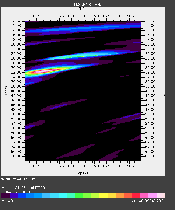
| Estimated Moho Depth: |
31.25 km |
| Estimated Crust Vp/Vs: |
1.69 |
| Assumed Crust Vp: |
6.468 km/s |
| Estimated Crust Vs: |
3.838 km/s |
| Estimated Crust Poisson's Ratio: |
0.23 |
|
| Radial Match: |
80.90352 % |
| Radial Bump: |
400 |
| Transverse Match: |
63.036552 % |
| Transverse Bump: |
400 |
| SOD ConfigId: |
29823551 |
| Insert Time: |
2022-11-30 22:52:01.160 +0000 |
| GWidth: |
2.5 |
| Max Bumps: |
400 |
| Tol: |
0.001 |
|

Signal To Noise
| Channel | StoN | STA | LTA |
| TM:SURA:00:HHZ:20221116T22:37:16.950009Z | 22.12299 | 1.682616E-6 | 7.6057354E-8 |
| TM:SURA:00:HHN:20221116T22:37:16.950009Z | 2.223229 | 3.206836E-7 | 1.4424226E-7 |
| TM:SURA:00:HHE:20221116T22:37:16.950009Z | 3.993365 | 6.65297E-7 | 1.666006E-7 |
| Arrivals |
| Ps | 3.4 SECOND |
| PpPs | 12 SECOND |
| PsPs/PpSs | 16 SECOND |


