You are here: Home > Network List > MN - MEDNET Project Stations List
> Station TIP Timpagrande, Italy > Earthquake Result Viewer
TIP Timpagrande, Italy - Earthquake Result Viewer
| Earthquake location: |
Peru-Brazil Border Region |
| Earthquake latitude/longitude: |
-8.5/-74.5 |
| Earthquake time(UTC): |
2010/01/25 (025) 22:52:46 GMT |
| Earthquake Depth: |
147 km |
| Earthquake Magnitude: |
5.7 MB, 5.9 MW, 5.9 MW |
| Earthquake Catalog/Contributor: |
WHDF/NEIC |
|
| Network: |
MN MEDNET Project |
| Station: |
TIP Timpagrande, Italy |
| Lat/Lon: |
39.18 N/16.76 E |
| Elevation: |
789 m |
|
| Distance: |
96.2 deg |
| Az: |
51.417 deg |
| Baz: |
264.18 deg |
| Ray Param: |
0.040448323 |
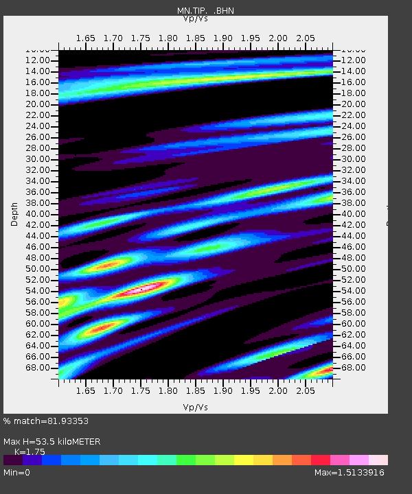
| Estimated Moho Depth: |
53.5 km |
| Estimated Crust Vp/Vs: |
1.75 |
| Assumed Crust Vp: |
6.1 km/s |
| Estimated Crust Vs: |
3.486 km/s |
| Estimated Crust Poisson's Ratio: |
0.26 |
|
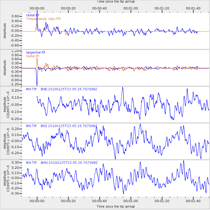
| Radial Match: |
81.93353 % |
| Radial Bump: |
400 |
| Transverse Match: |
94.358215 % |
| Transverse Bump: |
320 |
| SOD ConfigId: |
296938 |
| Insert Time: |
2010-04-06 23:18:23.341 +0000 |
| GWidth: |
2.5 |
| Max Bumps: |
400 |
| Tol: |
0.001 |
|
Signal To Noise
| Channel | StoN | STA | LTA |
| MN:TIP: :BHZ:20100125T23:05:26.707998Z | 1.567164 | 1.4964553E-7 | 9.548812E-8 |
| MN:TIP: :BHN:20100125T23:05:26.707998Z | 1.2611053 | 1.288538E-7 | 1.0217529E-7 |
| MN:TIP: :BHE:20100125T23:05:26.707998Z | 1.2689966 | 7.505423E-8 | 5.914455E-8 |
| Arrivals |
| Ps | 6.7 SECOND |
| PpPs | 24 SECOND |
| PsPs/PpSs | 30 SECOND |


