You are here: Home > Network List > US - United States National Seismic Network Stations List
> Station MSO Missoula, Montana, USA > Earthquake Result Viewer
MSO Missoula, Montana, USA - Earthquake Result Viewer
*The percent match for this event was below the threshold and hence no stack was calculated.
| Earthquake location: |
Santa Cruz Islands |
| Earthquake latitude/longitude: |
-11.7/166.6 |
| Earthquake time(UTC): |
2022/11/16 (320) 22:26:52 GMT |
| Earthquake Depth: |
138 km |
| Earthquake Magnitude: |
5.8 mww |
| Earthquake Catalog/Contributor: |
NEIC PDE/us |
|
| Network: |
US United States National Seismic Network |
| Station: |
MSO Missoula, Montana, USA |
| Lat/Lon: |
46.83 N/113.94 W |
| Elevation: |
1264 m |
|
| Distance: |
91.4 deg |
| Az: |
42.468 deg |
| Baz: |
254.383 deg |
| Ray Param: |
$rayparam |
*The percent match for this event was below the threshold and hence was not used in the summary stack. |
|
| Radial Match: |
54.1421 % |
| Radial Bump: |
400 |
| Transverse Match: |
57.36706 % |
| Transverse Bump: |
400 |
| SOD ConfigId: |
29823551 |
| Insert Time: |
2022-11-30 22:54:53.835 +0000 |
| GWidth: |
2.5 |
| Max Bumps: |
400 |
| Tol: |
0.001 |
|
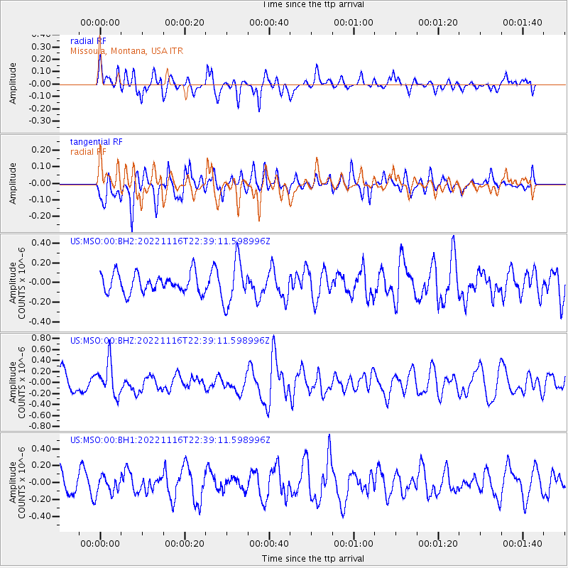
Signal To Noise
| Channel | StoN | STA | LTA |
| US:MSO:00:BHZ:20221116T22:39:11.598996Z | 1.9178667 | 3.0864143E-7 | 1.6092956E-7 |
| US:MSO:00:BH1:20221116T22:39:11.598996Z | 0.84764135 | 9.105853E-8 | 1.0742578E-7 |
| US:MSO:00:BH2:20221116T22:39:11.598996Z | 2.3951852 | 2.3114461E-7 | 9.650386E-8 |
| Arrivals |
| Ps | |
| PpPs | |
| PsPs/PpSs | |


