You are here: Home > Network List > AU - Australian Seismological Centre Stations List
> Station KLGHH Kalgoorlie Hampton Hill, WA ,GSWA network > Earthquake Result Viewer
KLGHH Kalgoorlie Hampton Hill, WA ,GSWA network - Earthquake Result Viewer
| Earthquake location: |
Southwest Of Sumatra, Indonesia |
| Earthquake latitude/longitude: |
-4.9/100.8 |
| Earthquake time(UTC): |
2022/11/18 (322) 13:37:08 GMT |
| Earthquake Depth: |
25 km |
| Earthquake Magnitude: |
6.9 mww |
| Earthquake Catalog/Contributor: |
NEIC PDE/us |
|
| Network: |
AU Australian Seismological Centre |
| Station: |
KLGHH Kalgoorlie Hampton Hill, WA ,GSWA network |
| Lat/Lon: |
30.75 S/121.75 E |
| Elevation: |
386 m |
|
| Distance: |
32.4 deg |
| Az: |
144.921 deg |
| Baz: |
318.306 deg |
| Ray Param: |
0.078644425 |
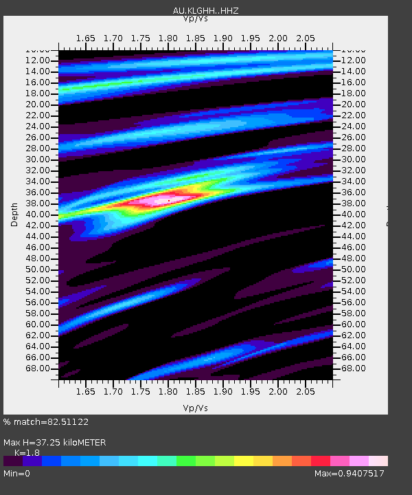
| Estimated Moho Depth: |
37.25 km |
| Estimated Crust Vp/Vs: |
1.80 |
| Assumed Crust Vp: |
6.459 km/s |
| Estimated Crust Vs: |
3.589 km/s |
| Estimated Crust Poisson's Ratio: |
0.28 |
|
| Radial Match: |
82.51122 % |
| Radial Bump: |
233 |
| Transverse Match: |
67.04374 % |
| Transverse Bump: |
400 |
| SOD ConfigId: |
29823551 |
| Insert Time: |
2022-12-02 13:38:36.654 +0000 |
| GWidth: |
2.5 |
| Max Bumps: |
400 |
| Tol: |
0.001 |
|

Signal To Noise
| Channel | StoN | STA | LTA |
| AU:KLGHH: :HHZ:20221118T13:43:05.939991Z | 2.5435324 | 2.0376326E-6 | 8.0110345E-7 |
| AU:KLGHH: :HHN:20221118T13:43:05.939991Z | 2.8040035 | 1.5656602E-6 | 5.58366E-7 |
| AU:KLGHH: :HHE:20221118T13:43:05.939991Z | 1.773979 | 6.9409214E-7 | 3.9126292E-7 |
| Arrivals |
| Ps | 5.0 SECOND |
| PpPs | 15 SECOND |
| PsPs/PpSs | 20 SECOND |


