You are here: Home > Network List > TA - USArray Transportable Network (new EarthScope stations) Stations List
> Station Y27A Causey, NM, USA > Earthquake Result Viewer
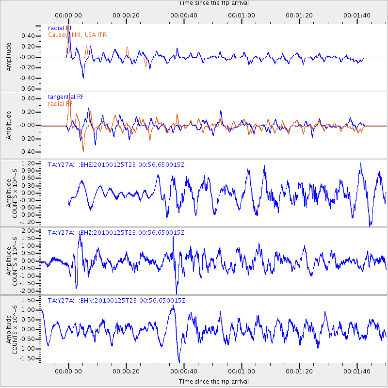
Y27A Causey, NM, USA - Earthquake Result Viewer
*The percent match for this event was below the threshold and hence no stack was calculated.
| Earthquake location: |
Peru-Brazil Border Region |
| Earthquake latitude/longitude: |
-8.5/-74.5 |
| Earthquake time(UTC): |
2010/01/25 (025) 22:52:46 GMT |
| Earthquake Depth: |
147 km |
| Earthquake Magnitude: |
5.7 MB, 5.9 MW, 5.9 MW |
| Earthquake Catalog/Contributor: |
WHDF/NEIC |
|
| Network: |
TA USArray Transportable Network (new EarthScope stations) |
| Station: |
Y27A Causey, NM, USA |
| Lat/Lon: |
33.88 N/103.16 W |
| Elevation: |
1253 m |
|
| Distance: |
50.2 deg |
| Az: |
328.663 deg |
| Baz: |
141.801 deg |
| Ray Param: |
$rayparam |
*The percent match for this event was below the threshold and hence was not used in the summary stack. |
|
| Radial Match: |
67.2706 % |
| Radial Bump: |
343 |
| Transverse Match: |
53.36029 % |
| Transverse Bump: |
280 |
| SOD ConfigId: |
296938 |
| Insert Time: |
2010-04-06 23:23:18.178 +0000 |
| GWidth: |
2.5 |
| Max Bumps: |
400 |
| Tol: |
0.001 |
|
Signal To Noise
| Channel | StoN | STA | LTA |
| TA:Y27A: :BHZ:20100125T23:00:56.650015Z | 4.3707185 | 9.4553536E-7 | 2.1633407E-7 |
| TA:Y27A: :BHN:20100125T23:00:56.650015Z | 0.45960915 | 1.9774588E-7 | 4.3024792E-7 |
| TA:Y27A: :BHE:20100125T23:00:56.650015Z | 2.0468132 | 4.8035906E-7 | 2.3468631E-7 |
| Arrivals |
| Ps | |
| PpPs | |
| PsPs/PpSs | |


