You are here: Home > Network List > IU - Global Seismograph Network (GSN - IRIS/USGS) Stations List
> Station PMG Port Moresby, New Guinea > Earthquake Result Viewer
PMG Port Moresby, New Guinea - Earthquake Result Viewer
| Earthquake location: |
Southwest Of Sumatra, Indonesia |
| Earthquake latitude/longitude: |
-4.9/100.8 |
| Earthquake time(UTC): |
2022/11/18 (322) 13:37:08 GMT |
| Earthquake Depth: |
25 km |
| Earthquake Magnitude: |
6.9 mww |
| Earthquake Catalog/Contributor: |
NEIC PDE/us |
|
| Network: |
IU Global Seismograph Network (GSN - IRIS/USGS) |
| Station: |
PMG Port Moresby, New Guinea |
| Lat/Lon: |
9.40 S/147.16 E |
| Elevation: |
90 m |
|
| Distance: |
46.2 deg |
| Az: |
98.28 deg |
| Baz: |
272.208 deg |
| Ray Param: |
0.07076727 |
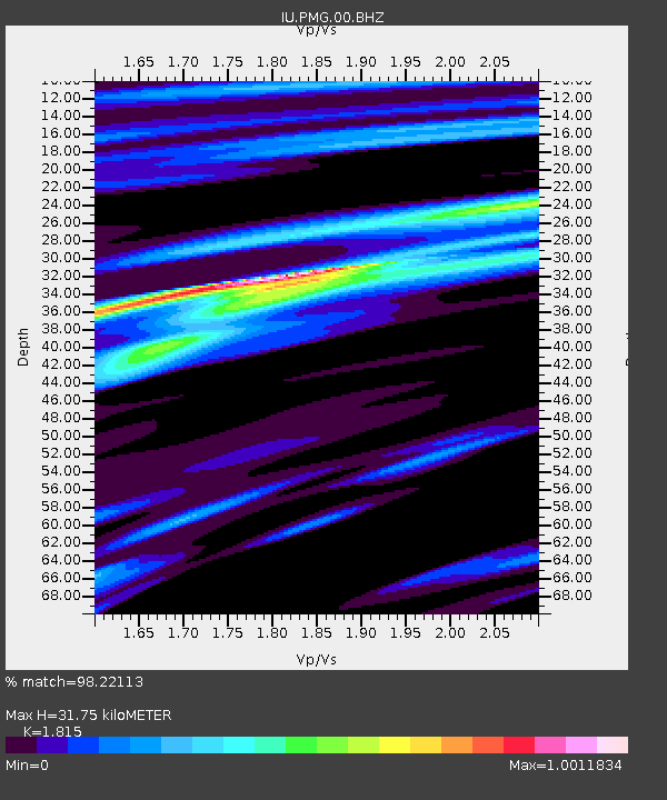
| Estimated Moho Depth: |
31.75 km |
| Estimated Crust Vp/Vs: |
1.82 |
| Assumed Crust Vp: |
6.122 km/s |
| Estimated Crust Vs: |
3.373 km/s |
| Estimated Crust Poisson's Ratio: |
0.28 |
|
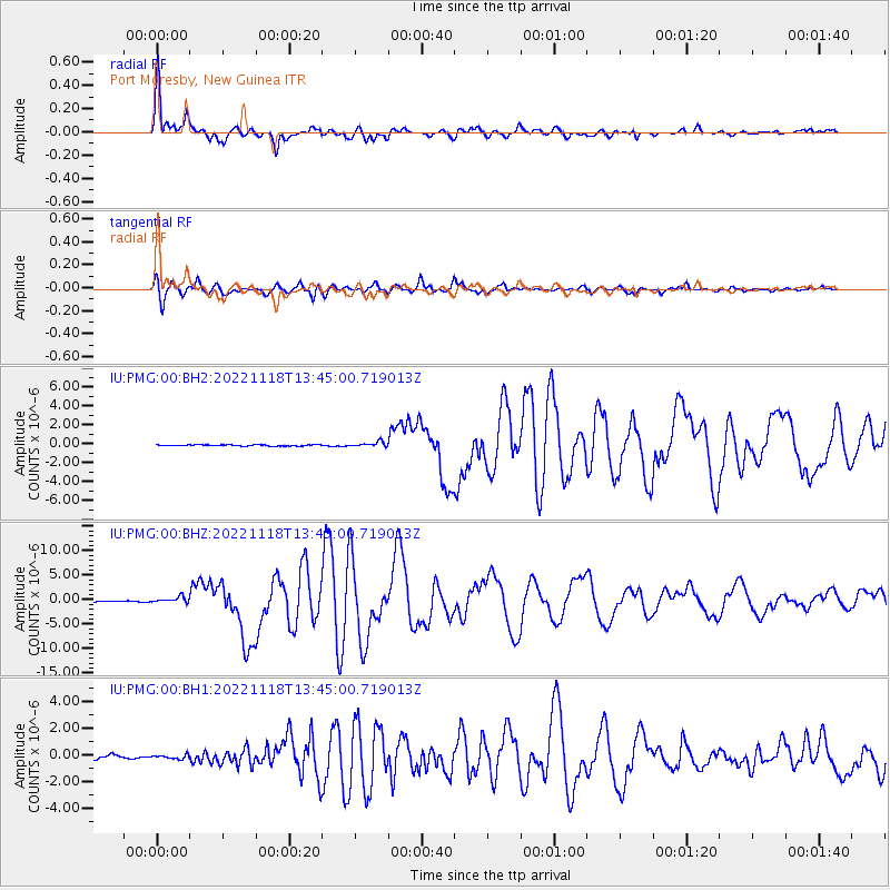
| Radial Match: |
98.22113 % |
| Radial Bump: |
400 |
| Transverse Match: |
96.6713 % |
| Transverse Bump: |
400 |
| SOD ConfigId: |
29823551 |
| Insert Time: |
2022-12-02 13:42:18.020 +0000 |
| GWidth: |
2.5 |
| Max Bumps: |
400 |
| Tol: |
0.001 |
|
Signal To Noise
| Channel | StoN | STA | LTA |
| IU:PMG:00:BHZ:20221118T13:45:00.719013Z | 6.427533 | 6.0407626E-7 | 9.398259E-8 |
| IU:PMG:00:BH1:20221118T13:45:00.719013Z | 1.4494576 | 1.5381687E-7 | 1.061203E-7 |
| IU:PMG:00:BH2:20221118T13:45:00.719013Z | 3.9236398 | 2.6192984E-7 | 6.6756854E-8 |
| Arrivals |
| Ps | 4.5 SECOND |
| PpPs | 14 SECOND |
| PsPs/PpSs | 18 SECOND |


