You are here: Home > Network List > IU - Global Seismograph Network (GSN - IRIS/USGS) Stations List
> Station ULN Ulaanbaatar, Mongolia > Earthquake Result Viewer
ULN Ulaanbaatar, Mongolia - Earthquake Result Viewer
| Earthquake location: |
Southwest Of Sumatra, Indonesia |
| Earthquake latitude/longitude: |
-4.9/100.8 |
| Earthquake time(UTC): |
2022/11/18 (322) 13:37:08 GMT |
| Earthquake Depth: |
25 km |
| Earthquake Magnitude: |
6.9 mww |
| Earthquake Catalog/Contributor: |
NEIC PDE/us |
|
| Network: |
IU Global Seismograph Network (GSN - IRIS/USGS) |
| Station: |
ULN Ulaanbaatar, Mongolia |
| Lat/Lon: |
47.87 N/107.05 E |
| Elevation: |
1610 m |
|
| Distance: |
52.8 deg |
| Az: |
5.292 deg |
| Baz: |
187.845 deg |
| Ray Param: |
0.06647218 |
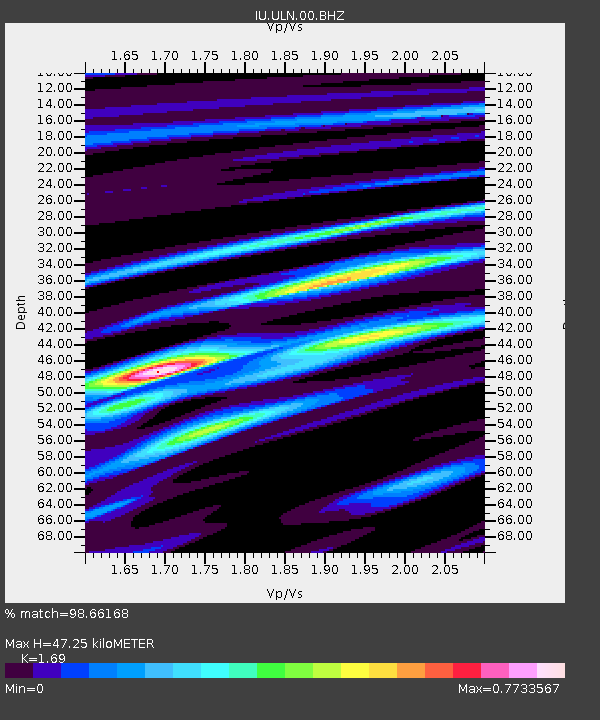
| Estimated Moho Depth: |
47.25 km |
| Estimated Crust Vp/Vs: |
1.69 |
| Assumed Crust Vp: |
6.642 km/s |
| Estimated Crust Vs: |
3.93 km/s |
| Estimated Crust Poisson's Ratio: |
0.23 |
|
| Radial Match: |
98.66168 % |
| Radial Bump: |
224 |
| Transverse Match: |
84.537674 % |
| Transverse Bump: |
400 |
| SOD ConfigId: |
29823551 |
| Insert Time: |
2022-12-02 13:42:23.233 +0000 |
| GWidth: |
2.5 |
| Max Bumps: |
400 |
| Tol: |
0.001 |
|
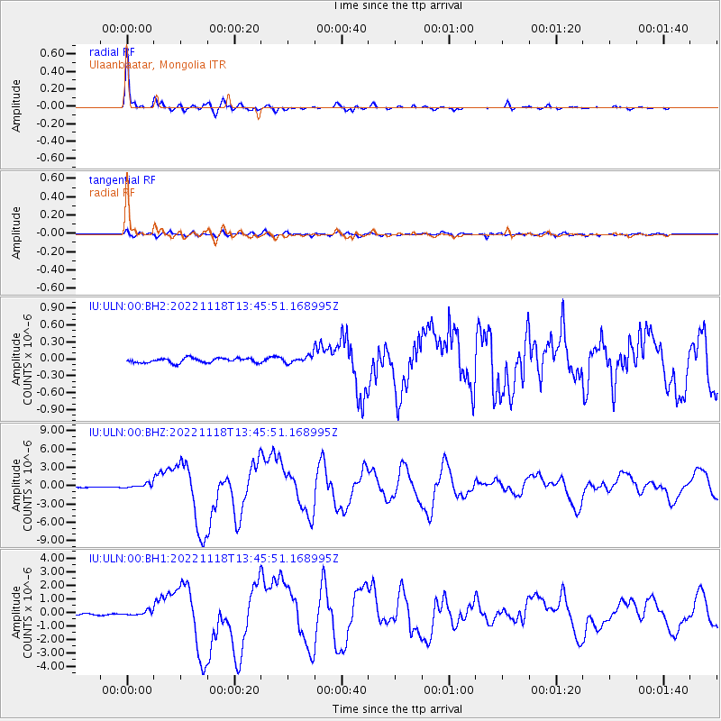
Signal To Noise
| Channel | StoN | STA | LTA |
| IU:ULN:00:BHZ:20221118T13:45:51.168995Z | 4.8079815 | 3.5172425E-7 | 7.315424E-8 |
| IU:ULN:00:BH1:20221118T13:45:51.168995Z | 4.084484 | 1.5687772E-7 | 3.8408206E-8 |
| IU:ULN:00:BH2:20221118T13:45:51.168995Z | 1.5327626 | 6.3085004E-8 | 4.1157715E-8 |
| Arrivals |
| Ps | 5.2 SECOND |
| PpPs | 18 SECOND |
| PsPs/PpSs | 23 SECOND |


