You are here: Home > Network List > JP - Japan Meteorological Agency Seismic Network Stations List
> Station JKA Kamikawa Asahi > Earthquake Result Viewer
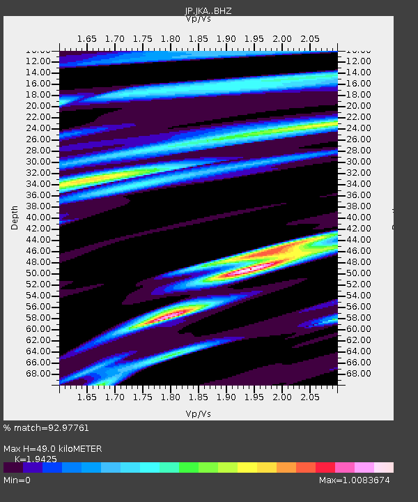
JKA Kamikawa Asahi - Earthquake Result Viewer
| Earthquake location: |
Southwest Of Sumatra, Indonesia |
| Earthquake latitude/longitude: |
-4.9/100.8 |
| Earthquake time(UTC): |
2022/11/18 (322) 13:37:08 GMT |
| Earthquake Depth: |
25 km |
| Earthquake Magnitude: |
6.9 mww |
| Earthquake Catalog/Contributor: |
NEIC PDE/us |
|
| Network: |
JP Japan Meteorological Agency Seismic Network |
| Station: |
JKA Kamikawa Asahi |
| Lat/Lon: |
41.12 N/142.59 E |
| Elevation: |
220 m |
|
| Distance: |
59.6 deg |
| Az: |
35.713 deg |
| Baz: |
230.337 deg |
| Ray Param: |
0.062023737 |
| Estimated Moho Depth: |
49.0 km |
| Estimated Crust Vp/Vs: |
1.94 |
| Assumed Crust Vp: |
6.183 km/s |
| Estimated Crust Vs: |
3.183 km/s |
| Estimated Crust Poisson's Ratio: |
0.32 |
|
| Radial Match: |
92.97761 % |
| Radial Bump: |
400 |
| Transverse Match: |
82.935104 % |
| Transverse Bump: |
400 |
| SOD ConfigId: |
29823551 |
| Insert Time: |
2022-12-02 13:42:31.127 +0000 |
| GWidth: |
2.5 |
| Max Bumps: |
400 |
| Tol: |
0.001 |
|

Signal To Noise
| Channel | StoN | STA | LTA |
| JP:JKA: :BHZ:20221118T13:46:52.850025Z | 0.8673901 | 1.6952595E-7 | 1.9544373E-7 |
| JP:JKA: :BHN:20221118T13:46:52.850025Z | 1.3922055 | 2.8008344E-7 | 2.0117966E-7 |
| JP:JKA: :BHE:20221118T13:46:52.850025Z | 0.8342567 | 2.0182893E-7 | 2.4192664E-7 |
| Arrivals |
| Ps | 7.8 SECOND |
| PpPs | 22 SECOND |
| PsPs/PpSs | 30 SECOND |


