You are here: Home > Network List > JP - Japan Meteorological Agency Seismic Network Stations List
> Station JTU Tsushima Kamiagata > Earthquake Result Viewer
JTU Tsushima Kamiagata - Earthquake Result Viewer
| Earthquake location: |
Southwest Of Sumatra, Indonesia |
| Earthquake latitude/longitude: |
-4.9/100.8 |
| Earthquake time(UTC): |
2022/11/18 (322) 13:37:08 GMT |
| Earthquake Depth: |
25 km |
| Earthquake Magnitude: |
6.9 mww |
| Earthquake Catalog/Contributor: |
NEIC PDE/us |
|
| Network: |
JP Japan Meteorological Agency Seismic Network |
| Station: |
JTU Tsushima Kamiagata |
| Lat/Lon: |
34.53 N/129.40 E |
| Elevation: |
70 m |
|
| Distance: |
47.6 deg |
| Az: |
32.368 deg |
| Baz: |
220.247 deg |
| Ray Param: |
0.06986051 |
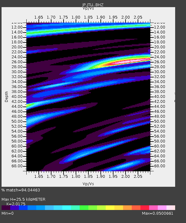
| Estimated Moho Depth: |
25.5 km |
| Estimated Crust Vp/Vs: |
2.02 |
| Assumed Crust Vp: |
6.472 km/s |
| Estimated Crust Vs: |
3.208 km/s |
| Estimated Crust Poisson's Ratio: |
0.34 |
|
| Radial Match: |
94.04463 % |
| Radial Bump: |
400 |
| Transverse Match: |
85.62017 % |
| Transverse Bump: |
400 |
| SOD ConfigId: |
29823551 |
| Insert Time: |
2022-12-02 13:42:42.333 +0000 |
| GWidth: |
2.5 |
| Max Bumps: |
400 |
| Tol: |
0.001 |
|

Signal To Noise
| Channel | StoN | STA | LTA |
| JP:JTU: :BHZ:20221118T13:45:11.650013Z | 2.3704221 | 9.189655E-7 | 3.876801E-7 |
| JP:JTU: :BHN:20221118T13:45:11.650013Z | 1.3768011 | 4.6015367E-7 | 3.342194E-7 |
| JP:JTU: :BHE:20221118T13:45:11.650013Z | 2.0309746 | 4.786355E-7 | 2.3566791E-7 |
| Arrivals |
| Ps | 4.2 SECOND |
| PpPs | 11 SECOND |
| PsPs/PpSs | 15 SECOND |


