You are here: Home > Network List > TA - USArray Transportable Network (new EarthScope stations) Stations List
> Station L24A Wheatland, WY, USA > Earthquake Result Viewer
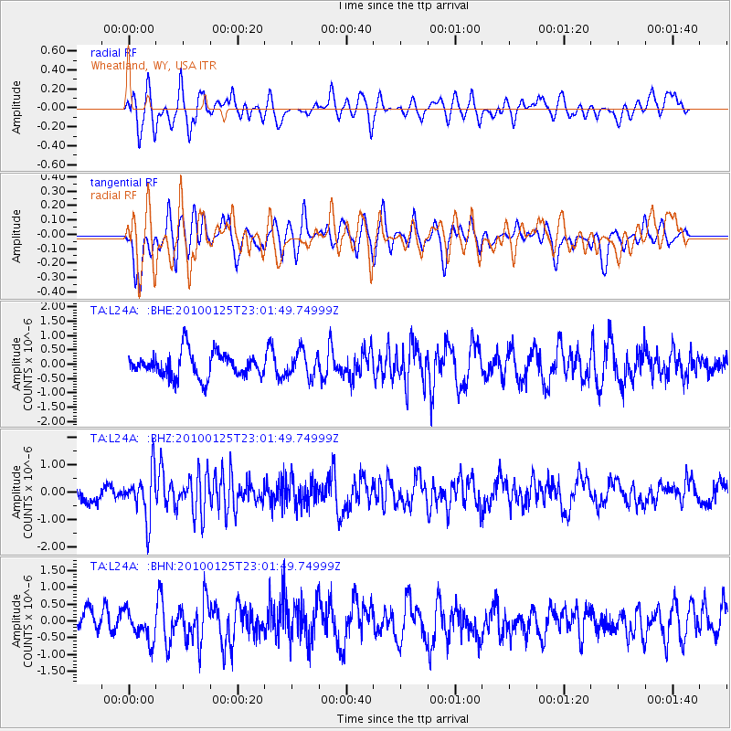
L24A Wheatland, WY, USA - Earthquake Result Viewer
*The percent match for this event was below the threshold and hence no stack was calculated.
| Earthquake location: |
Peru-Brazil Border Region |
| Earthquake latitude/longitude: |
-8.5/-74.5 |
| Earthquake time(UTC): |
2010/01/25 (025) 22:52:46 GMT |
| Earthquake Depth: |
147 km |
| Earthquake Magnitude: |
5.7 MB, 5.9 MW, 5.9 MW |
| Earthquake Catalog/Contributor: |
WHDF/NEIC |
|
| Network: |
TA USArray Transportable Network (new EarthScope stations) |
| Station: |
L24A Wheatland, WY, USA |
| Lat/Lon: |
42.04 N/104.93 W |
| Elevation: |
1479 m |
|
| Distance: |
57.5 deg |
| Az: |
333.401 deg |
| Baz: |
143.517 deg |
| Ray Param: |
$rayparam |
*The percent match for this event was below the threshold and hence was not used in the summary stack. |
|
| Radial Match: |
60.873413 % |
| Radial Bump: |
400 |
| Transverse Match: |
51.318268 % |
| Transverse Bump: |
400 |
| SOD ConfigId: |
296938 |
| Insert Time: |
2010-04-06 23:26:04.557 +0000 |
| GWidth: |
2.5 |
| Max Bumps: |
400 |
| Tol: |
0.001 |
|
Signal To Noise
| Channel | StoN | STA | LTA |
| TA:L24A: :BHZ:20100125T23:01:49.74999Z | 2.3706946 | 8.6769813E-7 | 3.6601008E-7 |
| TA:L24A: :BHN:20100125T23:01:49.74999Z | 1.266437 | 4.5286245E-7 | 3.5758782E-7 |
| TA:L24A: :BHE:20100125T23:01:49.74999Z | 1.0515552 | 4.4861682E-7 | 4.2662222E-7 |
| Arrivals |
| Ps | |
| PpPs | |
| PsPs/PpSs | |


